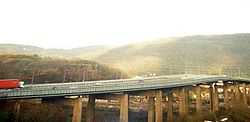
Briton Ferry Bridge
| Briton Ferry Bridge | |||
| Location Map ( geo) | |||
 | |||
| |||
| Location | |||
| Briton Ferry, South Wales | |||
| County | |||
| Glamorgan | |||
| Highway Authority | |||
| Neath Port Talbot | |||
| Opening Date | |||
| 1953 | |||
| Additional Information | |||
| |||
| On road(s) | |||
| A48 | |||
Briton Ferry Bridge is a high level crossing of the River Neath, to the east of Swansea on the A48, three-quarters of a mile long. It shortened the journey from Cardiff to Swansea by 6 miles by avoiding the need to go upstream to the river crossing at Neath. For many years it formed part of the Briton Ferry gap, between completed sections of the M4; however, it was finally bypassed by a completed M4 in 1993, just to the south.
Briton Ferry Bridge actually comprises two separate viaducts, one over the Neath River, and the other over Briton Ferry dock area. A ferry served the area in Roman times, and a regular ferry service operated in the first half of the 20th century.
Construction detail
The bridges formed the first part of the A48 Neath bypass scheme, designed by Rendel, Palmer & Tritton, a company which is still recognisably present in the UK market as Rendel Ltd, despite mergers and take overs. Sir Percy Thomas was the consulting architect. Construction of the two viaducts began in 1949, and they comprise a 17 span 585m long steel viaduct to the west and a 11 span 296m steel viaduct to the east. The bridges are linked by a short length of dual carriageway through a cutting of the small hill known as Warren Hill.
The bridges were built from steel on concrete piers by Cleveland Bridge and Engineering Company of Darlington (another company still in business). Overall width was 27.4m which include two 6.7m wide carriageways together with cycle tracks and footways.
Cost was £2 million and, when complete, it was the largest river bridge built in Britain since WW2.
The River Bridge
It is a cantilever bridge with the centre span suspended. The main span on this western bridge is 91.4m in length, and the main girders of this span extend above carriageway level as seen in the Streetview image here: https://goo.gl/maps/y2NP9cNci1N2. The road level over the Neath River is 30.5m above the highest Spring tide and allows a clearance to shipping of 27.4m. The high tensile girders of the bridge can take a 100 ton point-load.
In sinking the piers on which the bridge rests compressed air was used and the men were working in a pressure of 30lb. The cylinders were sunk to 24.4m below the river bed to find the rock for the foundations. A new feature was the monolith foundation construction on the wide saltings on the Earlswood (west) side of the river.
Opening
It was opened on 31 October 1955 by John Boyd-Carpenter, Minister of Transport and Civil Aviation. More than 5,000 onlookers gathered for the opening. One welcome guest was the man who had fallen off the bridge during its construction. Glyn Lloyd, a crane driver of Neith, had fell 35m from the centre span in June 1955. He suffered multiple injuries and was in hospital for 5 weeks. He said "I am as fit as a fiddle and indeed happy to be at the opening"
Links
Information in this article was sourced from a more detailed article at Engineering Timelines: http://www.engineering-timelines.com/scripts/engineeringItem.asp?id=1429
| Briton Ferry Bridge | ||
|
| Briton Ferry Bridge | ||
| ||
|
