Star.pngStar.pngStar grey.pngStar grey.pngStar grey.png

Buckbarn Crossroads

From Roader's Digest: The SABRE Wiki
(Redirected from Buck Barn Junction)
Jump to navigation Jump to search
Buckbarn Crossroads
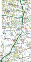
Location Map ( geo)
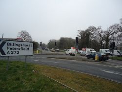
A24 near West Grinstead - Geograph - 2314961.jpg
Cameraicon.png View gallery (2)
Location
West Grinstead
County
Sussex
Highway Authority
National Highways
Junction Type
Traffic Light Controlled Offset Crossroads
Roads Joined
A24, A272

Buckbarn Crossroads, also known as Buck Barn is a crossroads between the A24 and A272. The A24 heads north to south as a dual carriageway while the A272 heads east to west on a single carriageway which has been offset. People typically are always in the wrong lane due to there being three lanes in every direction on top of each other due to it being traffic light controlled. In the late 1990s and early 2000s there were plans of putting a GSJ here, however in 2011 this was declined. Despite it being on two primary routes, the lights tend to not cause too much congestion.

The future of the junction is unclear for what will happen to the crossroads. Some plans suggest that it will become a GSJ, although the Horsham District Transport Study (2021) suggest for the junction to become a through-about hamburger junction, however with some additional dedicated bus priority infrastructure.


There is a plan for a new town south east of these crossroads, although information around this is still unclear but improvements to the A24 and A272 would be carried out including grade separation for the Buckbarn Crossroads.

Services

Buckbarn has got a services area where there is a McDonalds and petrol station. They entered/exited from the western side of the A272 and there is also an entrance from the A24 northbound.

Routes

Route To Notes

A24

Worthing Worthing Road

A24

London, Horsham, Crawley, Gatwick Airport (A264) Worthing Road

A272

Billingshurst, Petersfield Coolham Road

A272

Haywards Heath, Cowfold Cowfold Road
Buckbarn Services


Buckbarn Crossroads
Related Pictures
View gallery (2)
A24 near West Grinstead - Geograph - 2314961.jpgA24 improvements.png
Junctions on the A24 and A280
WorthingRichmond Road Junction • Chapel Road Roundabout • Teville Road Roundabout • Newland Road Roundabout • Sompting Avenue Junction • Broadwater Roundabout • South Farm Road Junction • Grove Lodge Roundabout • Offington Corner • Findon Gate
Worthing to A272Cross Lane Junction • Findon South Junction • Findon Roundabout • Findon North Junction • Highden • Washington South Junction • Washington Roundabout • Rock Crossroads • Kensetts Corner • Ashington Interchange • Dial Post South • Dial Post North • Partridge Green Turn • Buckbarn Crossroads
A272 to North HorshamCopsale Turn • Pollards Hill Roundabout • Hop Oast Roundabout • High Wood Hill Interchange • Farthings Hill Interchange • Robin Hood Roundabout • Great Daux Roundabout
North Horsham to DorkingWestons Junction • Kingsfold Junction • Clarks Green Roundabout • Coles Lane Junction • Beare Green Roundabout • Beare Green Junction • Holmwood Corner • South Holmwood Junction • North Holmwood Roundabout • Chart Lane Junction South • Chart Lane Junction North • Deepdene Roundabout
North of DorkingClapham Common • Tooting Bec • Tooting Broadway • Colliers Wood • The Woodstock • Queen Victoria • Organ Crossroads • The Quadrant • Knoll Rdbt • Beaverbrook Rdbt • Givens Grove Rdbt • Burford Bridge Rdbt
A280Findon Roundabout • Clapham Interchange • Water Lane Junction • Roundstone Roundabout
A272 Junctions
 • Tylers Green Roundabout  • Bolnore Roundabout  • Lower Village Roundabout  • Highbank Roundabout  • Sandrocks Roundabout  • Foxhill Roundabout  • The Birch Hotel Roundabout  • Bedales Corner  • Chownes Mead Junction  • Hilland Roundabout  • Hammonds Roundabout  


SABRE - The Society for All British and Irish Road Enthusiasts
Discuss - Digest - Discover - Help