C3-54 (North Ayrshire)
| C3-54 | ||||
| Location Map ( geo) | ||||
 | ||||
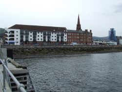
| Fort Street is between the sea wall and the buildings | ||||
| ||||
| From: | Bath Street (NS200593) | |||
| To: | Gallowgate Street (NS200594) | |||
| Via: | Fort Street | |||
| Distance: | 0.1 miles (0.2 km) | |||
| Meets: | B7025, A78 | |||
| Highway Authorities | ||||
| Traditional Counties | ||||
| Route outline (key) | ||||
| ||||
For other roads numbered C3, see C3.
The C3-54 follows the very short Fort Street in Largs. This is a one way street running along the shore to serve the Cumbrae Ferry pier.
The street is less than 160m long, but has two right angled turns in that short space. The first straight is from Bath Street, which is signposted from the A78 from the south as the route to the ferry (via Charles Street and Mackerston Place). Traffic from the north on the A78 also uses Bath Street to reach the ferry, but from the other side.
Some time since 2016, a dedicated ferry traffic lane has been marked in white paint on the north side of Bath Street, west of Fort Street. This same lane has double yellow lines.
After the first right turn, the longest stretch of the road is split into three lanes, the leftmost of which is painted yellow and states "Ferry Traffic Only", also painted in yellow. The central lane also has yellow painted "Ferry Traffic Only" lettering, but painted at right angles to the flow of traffic. The third lane is unmarked for most of its length and is used mainly by residents for parking.
The three lanes reduce to two near the ferry, the central lane being taken up by a viking longship sculpture, while the third lane has double yellow lines all the way to the A78 from here.
The last stretch of the road consists of two lanes in and two lanes out, with some traffic needing to cross lanes in the short space available. The lanes into this section are one for through traffic from Fort Street itself and another for traffic coming from the Cumbrae ferry which at certain states of the tide seems to dock on Fort Street itself.
Traffic leaving the street can turn left (north) or right onto the A78, Gallowgate Street.
| C3-54 (North Ayrshire) | ||||
| ||||
| ||||
|


