C503 (Sunderland)
| C503 | ||||
| Location Map ( geo) | ||||
 | ||||
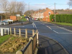
| Worm Hill Terrace | ||||
| ||||
| From: | Glebe (NZ303567) | |||
| To: | Penshaw (NZ324527) | |||
| Via: | Fatfield, Mount Pleasant | |||
| Distance: | 3.5 miles (5.6 km) | |||
| Meets: | A1231, A195, C502, A182, A183 | |||
| Former Number(s): | A182 | |||
| Highway Authorities | ||||
| Traditional Counties | ||||
| Route outline (key) | ||||
| ||||
For other roads numbered C503, see C503.
The C503 is a north-south route running through the new town of Washington to Penshaw, just outside the urban area of Sunderland. For much of its route, it broadly follows the former A182 before this was moved onto the grade-separated Washington Highway.
It begins at a roundabout interchange on the A1231, running south as a dual carriageway to another roundabout. This provides one of the two main accesses to The Galleries shopping centre, effectively the commercial centre of Washington. The C503 bears left and continues along Parkway, eventually curving gently right to join the former A182 as Fatfield Road. Continuing south, the road becomes Biddick Lane at a mini-roundabout and crosses the A195 at a roundabout. It continues through Fatfield before having to TOTSO onto Fallowfield Way. A curving dead end on the inside of this corner gives away that this was once the through route. Shortly afterwards the C503 has to TOTSO again, turning right onto Worm Hill Terrace and heading downhill towards the River Wear, which it crosses via Fatfield Bridge.
The C503 deviates from the line of the former A182 in Mount Pleasant, curving round to the right to access a junction on the modern bypass before turning left at a roundabout and returning to the pre-bypass route, climbing a steep hill towards the site of the old Penshaw Station. The railway overbridge remains, now carrying just a footpath, and the road bends sharply round to the right soon afterwards. The building of the Shiney Row Roundabout and Washington Highway truncated the former route of the A182 along Barrack Row, and the C503 now curves left then right to meet the roundabout.
| C503 (Sunderland) | ||||||||||||
| ||||||||||||
| ||||||||||||
|


