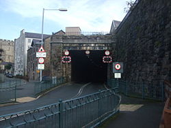
Caernarfon Tunnel
| Caernarfon Tunnel | |||
| Location Map ( geo) | |||
 | |||
| |||
| From: | St. Helen's Road, Caernarfon | ||
| To: | Crown Street, Caernarfon | ||
| County | |||
| Caernarfonshire | |||
| Highway Authority | |||
| Gwynedd | |||
| Opening Date | |||
| 1870(rail), 1998 (road) | |||
The Caernarfon Tunnel is a converted railway tunnel that enables traffic to cross the town centre avoiding the narrow streets of the old walled town and the detour to the A4871. The tunnel was originally built by the London North Western Railway company (latterly part of LMS) in 1870, connecting the mainline station to the north of the town centre with the Llanberis branchline and the line to Cricceth. It carried a twin track railway and appears to have been constructed as a cut and cover structure as the roof of the tunnel below Castle Square appears to be too thin for a bored tunnel. The southern portal is square cut with metal beams supporting the roof, but a short distance into the tunnel, an arched brick roof takes over and continues through to the northern portal. A short trenched section then follows, before the road reaches the surrounding ground level. The only buildings directly above the tunnel are relatively modern, and its alignment curves across the square between side streets.
The tunnel remained in use by the railway until closure in 1964. It then lay derelict for over thirty years before work was started to return it to use, with the road through the tunnel opening in 1998. At the southern portal it connects to a shared space roundabout on St Helens Street, where a lot of redevelopment has taken place in recent years, not least the construction of the new terminus for the Welsh Highland Railway, which uses the old trackbed of the Cricceth line as far as Dinas, from where it follows the old narrow gauge line through the mountains. The northern portal connects to Crown Street. After emerging from the tunnel, it follows a trenched section before passing under a long bridge carrying a surface street. Beyond this, ground level is generally lower, and the road ramps up slightly, curving around a car park to a mini roundabout on Balaclava Road.
The tunnel's main claim to fame is that it was used for a multi-vehicle accident site in the BBC programme Casualty.
| Caernarfon Tunnel | ||
|


