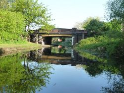
Castle Bridge (Wolverhampton)
Jump to navigation
Jump to search
| Castle Bridge | |||||||
| Location Map ( geo) | |||||||
 | |||||||
| Location | |||||||
| Wednesfield | |||||||
| County | |||||||
| Staffordshire | |||||||
| Highway Authority | |||||||
| Wolverhampton | |||||||
| Opening Date | |||||||
| 1795 | |||||||
| Additional Information | |||||||
| |||||||
| On road(s) | |||||||
| A4124 | |||||||
This article is about the bridge called Castle Bridge in Wednesfield, Staffordshire.
For for other bridges called Castle Bridge, see Castle Bridge.
For for other bridges called Castle Bridge, see Castle Bridge.
Castle Bridge takes the A4124 across the Wyrley and Essington Canal on the eastern side of Wednesfield. Not surprisingly, it is architecturally very similar to the other original bridges carrying the main route through the town along this stretch of canal, such as Wards Bridge.
| Castle Bridge (Wolverhampton) | ||
|
