Category:Images by C2r pictures
Jump to navigation
Jump to search
Media in category 'Images by C2r pictures'
The following 200 files are in this category, out of 956 total.
(previous page) (next page) 1944 Belgium - in Convoy.jpg 1,920 × 1,287; 110 KB
 1945 - Autobahn.jpg 1,900 × 1,278; 124 KB
 1945 - Marienkirche, Herford 52.1157799N 8.6874832E.jpg 1,812 × 1,200; 145 KB
 1945 - Summer - Tram on the streets in Ghent.jpg 1,860 × 1,317; 188 KB
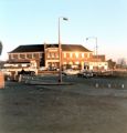
 197311 - Bottom of Maybank Avenue - view of Roundabout and Charlie Brown's Pub.jpg 1,032 × 1,014; 363 KB
 197311 - Charlie Brown's (The Roundabout Pub).jpg 984 × 1,026; 371 KB
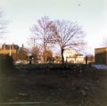 197311 - Child's Corner looking towards Buckhurst Hill.jpg 1,020 × 1,014; 384 KB
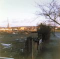 197311 - Childs Corner looking towards Ilford from the top of Maybank Avenue.jpg 1,020 × 1,002; 363 KB
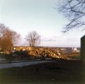
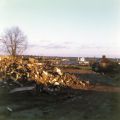 197311 - Remains of Block of Flats on Child's Corner (Maybank Avenue on Right).jpg 1,007 × 1,008; 373 KB
 197311 - Remains of the Block of Flats at Child's Corner.jpg 1,026 × 1,020; 382 KB
 197311 - Southend Road - Roof and tiles gone - Row of houses opposite Maybank Avenue.jpg 1,020 × 1,014; 402 KB
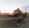 197311 - The Last Occupant in Maybank Avenue, Charlie Browns in background.jpg 1,020 × 1,014; 364 KB
 197311 - Traffic Lights at Child's Corner facing towards Ilford.jpg 1,026 × 1,008; 404 KB
 19801011 - Bowness 54.3626644N 2.9225309W.jpg 1,494 × 1,146; 596 KB
 198011 from Rose Avenue.jpg 1,518 × 1,170; 562 KB
 20030406-1630 - Route of new A10 at Thundridge looking South.jpg 640 × 480; 52 KB
 20040822-1525 - Marshalls Lane from High Cross to Sacombe Green 51.8511024N 0.0353172W.JPG 2,288 × 1,712; 2.02 MB
 20040905-1443 - A10 at Wadesmill being reconstructed.JPG 2,288 × 1,712; 2.07 MB
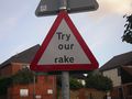 20040911-1834 - Braughing Ford - Try Our Rake.jpg 2,288 × 1,712; 2.47 MB
 20041001-1817 - Ferry Terminal, Douglas 54.1481439N 4.4764749W-small.jpg 1,716 × 1,284; 609 KB
 20041002-1113 - A18 TT Track and Tram Crossing 54.254334N 4.465770W-small.jpg 1,511 × 1,130; 435 KB
 20041218-1446 - Red Squirrels sign near Millbeck-small.jpg 1,831 × 1,370; 999 KB
 20041218-1525 - Crosthwaite Roundabout-small.jpg 687 × 514; 106 KB
 20050604-1224 - B1040 Delph Dyke between Whittlesea and North Side 1-small.jpg 2,074 × 1,556; 1.02 MB
 20090111-1108 - Standon Village.jpg 2,458 × 1,844; 1.2 MB
 20120604-1329 - A66 from Blencathra.jpg 3,072 × 2,304; 2.99 MB
 20120811-1227 - A4104 Little Malvern.jpg 3,072 × 2,304; 2.63 MB
 20140116-0817-ON=IMG-20140116-00166-.jpg 2,048 × 1,536; 606 KB
 20141008-1148 - Mam Tor - The Problem.jpg 3,072 × 2,304; 1.46 MB
 20150806-2043 - Storebaeltsbroen, Denmark 55.2974119N 10.8533693E.jpg 2,592 × 1,456; 1.03 MB
 20150808-1215 - Toldbodgade, Nyhavn, Copenhagen 55.67962N 12.59144E.jpg 3,072 × 2,304; 1.49 MB
 20150808-1534 - Borsgade 55.6758908N 12.5850427E.jpg 3,072 × 2,304; 1.55 MB
 20150808-1645 - Ny Ostergade 55.6804419N 12.5832039E.jpg 2,304 × 3,072; 1.54 MB
 20150809-1820 - Hjartsja from E134 - 59.6102442N 8.753587E.jpg 3,072 × 2,304; 1.74 MB
 20150809-1832 - E134 Flatdalvegen at 59.5738158,8.5587697.jpg 3,072 × 2,304; 1.56 MB
 20150811-0937 - Langedalen - 60.228768N 5.4220225E.jpg 2,304 × 3,072; 1.6 MB
 20150811-1003 - Rv546 - Krokeide Slipway 60.2250307N 5.289629E.jpg 3,072 × 2,304; 1.58 MB
 20150811-1242 - E134 Auto Toll 59.461536N 5.482267E.jpg 3,072 × 2,304; 1.55 MB
 20150811-1323 - Gjerdesdalsvatnet from Rv46 59.508417N 5.7697015E.jpg 3,072 × 2,304; 1.52 MB
 20150811-1404 - Rv46 from Ropeid slipway - looking West - 59.4852093N 6.2130432E.jpg 3,072 × 2,304; 1.52 MB
 20150811-1445 - Rv13 looking south between Sand and Erfjord - 59.4451902N 6.2391507E.jpg 2,304 × 3,072; 1.45 MB
 20150811-1450 - No Tomming - Rv13 Lovrafjord - 59.4256829N 6.2229644E.jpg 3,072 × 2,304; 1.64 MB
 20150811-1450 - Rv13 looking north at Lovrafjord - 59.4256829N 6.2229644E.jpg 2,304 × 3,072; 1.5 MB
 20150811-1705 - Fv435 bridge, Stavanger, Norway.jpg 3,072 × 2,304; 1.53 MB
 20150811-1707 - Fv435 bridge, Stavanger, Norway 2.jpg 2,304 × 3,072; 1.65 MB
 20150811-1708 - IMGP4110.jpg 2,304 × 3,072; 1.67 MB
 20150811-1926 - IMGP4116.jpg 2,304 × 3,072; 1.58 MB
 20151020-0814 - Reigate Church Street - 51.2378927N 0.2044731W.jpg 1,456 × 2,592; 799 KB
 20151028-0825 - Single Track lane near Northallerton - 54.2992386N 1.4457901W.jpg 2,592 × 1,456; 1.18 MB
 20151110-0818- Imperial Sign with no inches 51.4158837N 0.7482222W.jpg 2,592 × 1,456; 1,015 KB
 20151110-0821- Met Office Roundabout Sign.jpg 2,592 × 1,456; 1.33 MB
 20151110-0857 - Met Office Roundabout and Weather Way.jpg 2,592 × 1,456; 1.08 MB
 20151110-0859 - The Ring at Weather Way Junction, Bracknell - 51.417237N 0.7460732W.jpg 1,456 × 2,592; 1.12 MB
 20151110-1532 - One Way (or not) 51.4169984N 0.7467496W.jpg 1,456 × 2,592; 1.34 MB
 20151110-1533 - Non standard gantrry 51.416204N 0.7469267W.jpg 1,456 × 2,592; 914 KB
 20151205-1420 - A11 Northbound at Worsted Lodge - TL52825 51883.jpg 3,072 × 2,304; 1.7 MB
 20151205-1420 - A11 Southbound at Worsted Lodge - TL52825 51883.jpg 3,072 × 2,304; 1.63 MB
 20151215-0849 - Woking Martian 2 51.3206796N 0.5570266W.jpg 1,456 × 2,592; 1.13 MB
 20151217-0046 - Roundabout, Leeds 53.7786224N 1.5805676W.jpg 2,592 × 1,456; 1.43 MB
 20151219-1254 - Road at Mam Tor.jpg 3,072 × 2,304; 1.66 MB
 20151219-1254 - Roads at Winnats Head from Mam Tor.jpg 3,072 × 2,304; 1.54 MB
 20151220-1010 - A57 at Hagg Farm 53.3945169N 1.7576904W.jpg 3,072 × 2,304; 1.65 MB
 20151220-1011 - A57 at Hagg Farm 53.3945169N 1.7576904W.jpg 3,072 × 2,304; 1.63 MB
 20151220-1231 - Hern Side - SK169923.jpg 3,072 × 2,304; 1.51 MB
 20160119-0910 - Market Place, Oakham 2 - 52.670151N 0.7273948W.jpg 2,592 × 1,456; 1.1 MB
 20160119-0911 - Market Place, Oakham - 52.6700694N 0.7273219W.jpg 2,592 × 1,456; 1.02 MB
 20160121-0840 - B1039 Clanver End Fingerpost 52.0034754N 0.1788197E.jpg 2,592 × 1,456; 1.12 MB
 20160121-0841 - B1039 Newland End Fingerpost 52.0085104N 0.1664229E.jpg 1,456 × 2,592; 775 KB
 20160121-0844 - B1039 Duddenhoe End Fingerpost 52.0189498N 0.1452777E.jpg 2,592 × 1,456; 790 KB
 20160121-0846 - B1039 Wenden Lofts Fingerpost 52.0209365N 0.140303E.jpg 1,456 × 2,592; 747 KB
 20160121-0848 - B1039 Pond Street Fingerpost 52.0201189N 0.1264301E.jpg 1,456 × 2,592; 1.21 MB
 20160121-0848 - Road from B1039 to Duddenhoe End 52.0201189N 0.1264301E.jpg 1,456 × 2,592; 1.19 MB
 20160121-0850 - B1039 Chrishall Fingerpost 52.0237714N 0.1108177E.jpg 2,592 × 1,456; 968 KB
 20160121-0851 - B1039 Builden End Fingerpost 52.0235956N 0.1039828E.jpg 2,592 × 1,456; 957 KB
 20160124-1207 - Barley Fingerpost 1 52.0215994N 0.050838E.jpg 2,592 × 1,456; 1.83 MB
 20160124-1208 - Barley Fingerpost 2 52.0216255N 0.0509728E.jpg 2,592 × 1,456; 2.03 MB
 20160124-1209 - No Through Road Pre Warboys 52.0218274N 0.0518005E.jpg 1,456 × 2,592; 1.65 MB
 20160124-1213 - Great Chishill Fingerpost 52.0295981N 0.0720286E.jpg 2,592 × 1,456; 1.17 MB
 20160124-1220 - B1039 Great Chishill Windmill 52.0294206N 0.0537115E.jpg 1,456 × 2,592; 1.06 MB
 20160124-1227 - B1368 - Fox and Hounds, Barley 52.0262475N 0.0391164E.jpg 2,592 × 1,456; 881 KB
 20160124-1227 - No Through Road at Barley 52.0262929N 0.0394205E.jpg 2,592 × 1,456; 1.7 MB
 20160124-1229 - B1039 TOTSO 2 Barley 52.0277168N 0.0436707E.jpg 2,592 × 1,456; 1.65 MB
 20160124-1229 - B1039 TOTSO Barley 52.0277047N 0.0436934E.jpg 2,592 × 1,456; 1.13 MB
 20160124-1230 - B1039-B1368 crossroads Barley 52.03173N 0.0397631E.jpg 2,592 × 1,456; 1.34 MB
 20160124-1233 - B1039 looking towards Barley.jpg 1,456 × 2,592; 1.03 MB
 20160124-1240 - Grossalmerode 798km sign on A10 Royston Town Hall.jpg 2,592 × 1,456; 1.36 MB
 20160130-1414 - No Overtaking sign, N52 Dundalk - 54.009486N 6.391978W.jpg 1,456 × 2,592; 1.25 MB
 20160130-1415 - N52 Dundalk - Island Ahead - 54.0096929N 6.3922537W.jpg 1,456 × 2,592; 1.52 MB
 20160130-1417 - N52 bridge over Castletown River, Dundalk - 54.0112394N 6.3921708W.jpg 1,456 × 2,592; 1.33 MB
 20160130-1430 - Dundalk Stadium - 54.0169058N 6.3871929W.jpg 1,456 × 2,592; 1.31 MB
 20160130-1432 - T Junction Sign - N52 Dundalk - 54.016907N 6.3853015W.jpg 2,592 × 1,456; 1.6 MB
 20160130-1433 - No Entry Signs - Dundalk Racecourse - 54.0174947N 6.3850178W.jpg 2,592 × 1,456; 1.43 MB
 20160130-1435 - Dundalk Racecourse - 54.0183143N 6.384201W.jpg 2,592 × 1,456; 1.13 MB
 20160130-1447 - Warning Sign 54.0167512N 6.376339W.jpg 1,456 × 2,592; 1.32 MB
 20160130-1508 - Out on the marshes - 54.0163288N 6.3696369W.jpg 1,456 × 2,592; 1.42 MB
 20160130-1517 - Road narrows - 54.0161001N 6.3796096W.jpg 1,456 × 2,592; 1.16 MB
 20160130-1526 - Dundalk Gateway Sign - 54.0156398N 6.3884737W.jpg 1,456 × 2,592; 994 KB
 20160130-1527 - N52 Traffic Calming Ahead 54.0149676N 6.3889502W.jpg 1,456 × 2,592; 880 KB
 20160201-1249 - Walworth Road 54.5563957N 1.6509499W.jpg 2,592 × 1,456; 772 KB
 20160202-1058 - Finger Post on Houghton Bank Lane 54.5908815N 1.6540497W.jpg 2,592 × 1,456; 1.1 MB
 20160203-0925 - Main Street, Sedbergh (A684) 54.3235736N 2.528461W.jpg 1,456 × 2,592; 1 MB
 20160303-0837 - Kingston Bridge from Riverside Walk 51.4108713N 0.3081593W.jpg 2,592 × 1,456; 1.07 MB
 20160303-0841 - Clattern Bridge, Kingston Sign - 51.4086214N 0.3068083W.jpg 1,456 × 2,592; 1.63 MB
 20160411 0855 - Underneath the Hammersmith Flyover 51.4911633N 0.2250096W.jpg 2,592 × 1,456; 1.43 MB
 20160411 0905 - Hammersmith Flyover - 51.4911449 0.2259483W.jpg 1,456 × 2,592; 956 KB
 20160419 0846 - Kennel Corner, Ringmer - 50.8969072N 0.075158E - cropped.jpg 2,592 × 1,278; 1.37 MB
 20160419 0853 - Earwig Corner - 50.8844879N 0.022580E - cropped.jpg 1,451 × 1,537; 510 KB
 20160419 1909 - A46 51.6208525N 2.2695243W.jpg 2,592 × 1,456; 1.86 MB
 20160419 2328 - Steam Train Sign, Fishguard - 52.009098N 4.990368W.jpg 2,592 × 1,456; 1.48 MB
 20160421 1920 - Slipway at Greenore - 54.031558N 6.131593W.jpg 2,592 × 1,456; 840 KB
 20160421 1923 - Beach Cafe, Greenore 54.0317524N 6.1309617W.jpg 2,592 × 1,456; 1.35 MB
 20160421 1924 - R175 Greenore 54.0319446N 6.1309483W.jpg 2,592 × 1,456; 920 KB
 20160421 1930 - Start of R175 at Greenore 54.0334931N 6.1316957W.jpg 2,592 × 1,456; 964 KB
 20160422 0918 - R171 - 53.9714699N 6.4868541W.jpg 2,592 × 1,456; 1.02 MB
 20160422 0927 - M1 J18 500m fork (northbound) 54.0365203N 6.404127W.jpg 2,592 × 1,456; 935 KB
 20160422 0957 - Hillsborough Roundabout 54.4718286N 6.0819949W.jpg 2,592 × 1,456; 899 KB
 20160422 1428 - Commercial Court, Belfast - 54.601678N 5.9278819W.jpg 1,456 × 2,592; 1.16 MB
 20160422 1433 - Hill Street, Belfast 54.6019556N 5.9270842W.jpg 1,456 × 2,592; 1.02 MB
 20160422 1634 - Maryville Avenue, Belfast 54.575295N 5.9560951W.jpg 2,592 × 1,456; 1.21 MB
 20160422 1700 - Lisburn Road, Belfast 54.5753347N 5.9555386W.jpg 2,592 × 1,456; 1.2 MB
 20160422 1822 - N1 Ravensdale Junction 54.0681122N 6.3499398W.jpg 2,592 × 1,456; 1.12 MB
 20160422 1822 - Ravensdale Junction (N1 Southbound Exit) - 54.0700382N 6.3506139W.jpg 2,592 × 1,456; 957 KB
 20160422 1823 - R174 Ravensdale 54.067824N 6.3483546W.jpg 2,592 × 1,456; 1.01 MB
 20160422 1823 - R174 Ravensdale 54.0679934N 6.3495132W.jpg 2,592 × 1,456; 1.3 MB
 20160422 1824 - R174 Bend Ahead arrow 54.0683569N 6.345744W.jpg 2,592 × 1,456; 1.41 MB
 20160422 1824 - R174 Ravensdale - 54.0684144N 6.3452646W.jpg 2,592 × 1,456; 1.96 MB
 20160422 1825 - R174 Ravensdale 54.0589697N 6.3405444W.jpg 2,592 × 1,456; 1.3 MB
 20160422 1825 - R174 Ravensdale 54.0607922N 6.3420524W.jpg 2,592 × 1,456; 1.29 MB
 20160422 1828 - Chopsticks Flag Sign, Ravensdale 54.050778N 6.3556114W.jpg 2,592 × 1,456; 1.29 MB
 20160422 1829 - R132 Ravensdale End of Hard Shoulder 54.0456812N 6.3635238W.jpg 2,592 × 1,456; 1.36 MB
 20160422 1839 - R178 Dundalk 53.9941813N 6.4484201W.jpg 2,592 × 1,456; 991 KB
 20160422 1839 - R178 junction outside Dundalk 53.9942305N 6.4482832W.jpg 2,592 × 1,456; 1.12 MB
 20160422 1841 - R178 heading out of Dundalk 53.9904628N 6.4723843W cropped.jpg 2,507 × 1,309; 1.37 MB
 20160422 1841 - R178 heading out of Dundalk 53.9908051N 6.4712301W cropped.jpg 2,555 × 1,323; 993 KB
 20160422 1842 - L3136 Bumps sign - 53.9851566N 6.4969172W.jpg 2,592 × 1,456; 1.1 MB
 20160605-1552 - A1 Wyboston Services - 52.1927176N 0.2989956W.jpg 2,592 × 1,456; 940 KB
 20160605-1641 - Return to Grantham - 52.891378N 0.638298W.jpg 2,592 × 1,456; 1 MB
 20160605-1642 - King 31 Distribution Park Roundabout - 52.891378N 0.638298W.jpg 2,592 × 1,456; 1.01 MB
 20160605-1642 - Return to Grantham - 52.891378N 0.638298W.jpg 1,456 × 2,592; 1.03 MB
 20160605-1643 - Grantham Southern Bypass looking west - 52.891378N 0.638298W.jpg 2,592 × 1,456; 1.06 MB
 20160605-1644 - ADS for A1, Grantham Southern Bypass - 52.890649N 0.642045W.jpg 1,456 × 2,592; 1.19 MB
 20160605-1644 - Approaching A1, Grantham Southern Bypass - 52.890960N 0.640674W.jpg 2,592 × 1,456; 984 KB
 20160605-1646 - Cats Eye - 52.890960N 0.640674W.jpg 1,456 × 2,592; 1.94 MB
 20160605-1646 - View East back to King 31 Roundabout - 52.890960N 0.640674W.jpg 2,592 × 1,456; 1.04 MB
 20160605-1648 - Balancing Pond - 52.891317N 0.639320W.jpg 2,592 × 1,456; 1.42 MB
 20160605-1648 - King 31 roundabout 52.891317N 0.639320W.jpg 2,592 × 1,456; 912 KB
 20160605-1649 - Nice internally illuminated sign - 52.891317N 0.639320W.jpg 1,456 × 2,592; 1.06 MB
 20160605-1653 - B1174 realignment - looking south - 52.8916842N 0.633576W.jpg 2,592 × 1,456; 795 KB
 20160605-1653 - B1174 roundabout - 52.8915967N 0.634421W.jpg 2,592 × 1,456; 1.11 MB
 20160605-1902 - A6055 looking south towards Leeming Junction - 54.317653N 1.573826W.jpg 2,592 × 1,456; 880 KB
 20160605-1904 - A6055 looking north - 54.330566N 1.587457W.jpg 2,592 × 1,456; 738 KB
 20160605-1906 - A6055 junction with Bowbridge Lane - 54.335758N 1.593903W.jpg 2,592 × 1,456; 1.1 MB
 20160605-1908 - A1 from A6055 overbridge looking north - 54.339121N 1.598764W.jpg 2,592 × 1,456; 972 KB
 20160605-1908 - A1 from A6055 overbridge looking south - 54.339121N 1.598764W.jpg 2,592 × 1,456; 887 KB
 20160605-1908 - A6055 overbridge over A1M - 54.339121N 1.598764W.jpg 2,592 × 1,456; 1.16 MB
 20160605-1920 - Catterick Lane approaching A1(M) bypass - 54.3656801N 1.6359857W.jpg 1,456 × 2,592; 1.7 MB
 20160605-1931 - Tunstall Road Bridge over A1 looking West - 54.3727566N 1.6354917W.jpg 2,592 × 1,456; 1.31 MB
 20160605-1933 - View north from Tunstall Road A1 bridge - 54.3720976N 1.6365024W.jpg 2,592 × 1,456; 804 KB
 20160605-1933 - View south from Tunstall Road Bridge of old A1 - 54.3720976N 1.6365024W.jpg 2,592 × 1,456; 1.04 MB
 20160605-1937 - New Catterick Lane bridge over A1M - 54.370389N 1.636006W.jpg 2,592 × 1,456; 911 KB
 20160605-1938 - New Catterick Lane bridge over the motorway - 54.370389N -1.636006W.jpg 2,592 × 1,456; 1.07 MB
 20160605-1943 - A1M looking south to existing Catterick Lane - 54.368787N 1.634501W.jpg 2,592 × 1,456; 941 KB
 20160605-1946 - A1M looking south from Catterick Lane - 54.368375N 1.634180W.jpg 2,592 × 1,456; 1.19 MB
 20160605-1950 - A1M south of Catterick Lane looking north - 54.366810N 1.632070W.jpg 2,592 × 1,456; 1,005 KB
 20160605-1950 - A1M south of Catterick Lane looking south - 54.366810N 1.632070W.jpg 2,592 × 1,456; 1.14 MB
 20160605-1957 - accommodation bridge over new motorway from A1 - 54.362932N 1.627954W.jpg 2,592 × 1,456; 1,014 KB
 20160605-1959 - Accommodation Bridge - 54.362932N 1.627954W.jpg 2,592 × 1,456; 1.06 MB


.jpg)


.jpg)

_from_the_field_at_the_bottom_of_Maybank_Avenue.jpg)


-compressed.jpg)


_51.4169984N_0.7467496W.jpg)


_54.3235736N_2.528461W.jpg)


_52.6695362N_0.726595W.jpg)


_54.0365203N_6.404127W.jpg)


_-_54.0700382N_6.3506139W.jpg)


_bypass_-_54.3656801N_1.6359857W.jpg)


