Catthorpe Interchange
| Catthorpe | |||
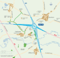
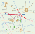
| Location Map ( geo) | |||
 | |||
| |||
| Location | |||
| Catthorpe | |||
| County | |||
| Leicestershire | |||
| Highway Authority | |||
| National Highways | |||
| Junction Type | |||
| Fork | |||
| Roads Joined | |||
| M1 (junction 19), M6, A14 | |||
The Catthorpe Interchange is a major motorway and trunk road junction in the Midlands, named after the nearby village of Catthorpe. It marks the starting point of the M6 and the A14, meeting at Junction 19 of the M1.
Originally constructed as a fork junction where the M1 and M6 split (with the local route running underneath), it was adapted during construction of the A14 in 1994. Due to budget constraints, a simple roundabout interchange was built, using the local road to link together the major routes. As such the junction became quickly overloaded and was an accident blackspot and regular point of congestion. In 2014 works began to adapt the junction to replace the roundabout with limited free-flow links. The links to the local road and between the M6 and M1 north have now been closed.
The link road from the M1 to the M6 (direction not known) was used to film an episode of Z-Cars, which was recorded before the road opened. That footage is possibly the earliest film of the motorway network here recorded.
History
In the beginning
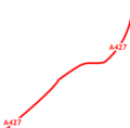
Once upon a time there was no junction here, just the Rugby Road, which at that time was the A427 passing through open countryside.
Early motorway era
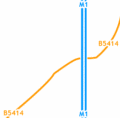
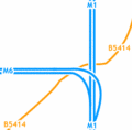
In 1965, the M1 motorway was constructed over the road, though there was no junction at this point, so all is still well with the world. Even with the coming of the M6 in 1971, there was still no problem. The junction was a simple fork between the M1 and M6. In 1988 permission was granted for a service area here, but was never developed.
The A14
It was the coming of the A14 in 1994 that caused problems at this junction. The existing (now unclassified) road under the junction was modified to handle all of the A14's traffic interchanging with the M1 and M6. Originally constructed as two separate roundabouts either side of the M1, the roundabouts became a single "teardrop" roundabout to try and reduce accidents.
Catthorpe in 1922
Catthorpe in 1965
Catthorpe in 1971
Catthorpe in 2010


2011 replacement viaduct
In the late 2000s it became apparent that the M6 southbound viaduct over the M1 was coming to the end of its operational life. The (at the time) proposed junction works to improve the A14 access to the motorway network were pushed back several times, owing to the ongoing planning process and issues with Government funding. Prior to agreement on construction, the Highways Agency were forced to act so in 2011, the existing viaduct was demolished and replaced with a new viaduct adjacent to it (BBC News). The Highways Agency confirmed the replacement viaduct would be in the correct position for the proposed junction redesign.
2014-17 redevelopment
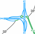
As a result of the junction's accident record and congestion, the Highways Agency began plans to redevelop the junction in December 2000. When the plans came back, they all included carrying the mainline M6 onto the A14. There was some criticism about the red and brown junction plans due to the A14-M1 south movement not being catered for.
Blue junction and green local road network
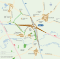
Brown junction and green local road network
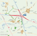
Red junction and green local road network
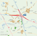
Red junction and orange local road network
Red junction and purple local road network


In 2003, the Highways Agency stated that the proposed improvement scheme "allows for" the A14 to be upgraded to motorway.
Preferred route
The preferred route was announced on 19th February 2009 by the Highways Agency. 57% of respondents voted for the red junction, the next one down being the blue junction at 39%. The brown junction received just 3% of the vote, and the final 1% had no preference.
The local road network options were slightly more split - 43% opted for the orange network, 34% for the green network, 14% had no preference, and 9% voted for the purple network.
The preferred route was announced to be the red junction and orange local road network, which had the most public support, has the lowest environmental impact, requires the least land, has the greatest traffic benefits, and represents good value for money, according to the Highways Agency
The draft orders were publicised in December 2009, and subject to statutory processes being completed, work was due to start in Summer 2011. The preferred route is shown below.

Construction
Work began in January 2014, and was due to finish by Autumn 2016. By January 2017 the new links were all open, although some associated works were still continuing.
Spontaneous motorway
The upgraded junction created a spontaneous motorway, because the exit from the A14 to Catthorpe and Swinford had been removed, meaning traffic heading west on the A14 can now only join a motorway: either the M1 north or the M6 north-west.
The exact point the motorway begins is immediately east of the M1/M6 split, making the start of motorway regulations "spontaneous" because it does not come immediately after an exit for non-motorway traffic.
Purists would point out that the motorway regulations should now begin at A14 J1, as this is the last point non-motorway traffic can leave. This is several miles outside the works boundary and would have incurred significant legal fees had the road been upgraded. Instead, signs at the junction now advise traffic that the road ahead leaves inescapably to a motorway. During the upgrade, signs in lay-bys advised any non-motorway traffic heading towards the motorway to pull over. To mitigate any trouble from this spontaneous motorway, a gated emergency exit sliproad was added to link the A14 westbound to M1 northbound onslip to Rugby Road. This allows non-motorway to escape the spontaneous motorway but they will have to use the emergency exit sliproad under police escort.
As there is no minimum physical standard for a motorway, the standard of the A14 would not have prevented an upgrade. Pedestrian crossings on the A14 between J1 and Catthorpe were removed as part of a separate project.
The fact that the junction upgrade has created this spontaneous motorway by moving the slip roads but not the regulations is not unique. The same situation applies at M56 J16 and A1(M) J34, but in both cases the length of the offending road is much shorter.
Routes
| Route | To | Notes |
| THE SOUTH, London, Northampton | ||
| THE NORTH, Leicester | ||
| THE NORTH WEST, Birmingham, Coventry | ||
| Felixstowe, Corby, Kettering | ||
| Catthorpe 1/2 | ||
| Swinford | 7.5 t weight limit | |
| THE SOUTH, London, Northampton | unsigned, uses M1 | |
| THE NORTH, Leicester | unsigned, uses M1 | |
| THE NORTH WEST, Birmingham, Coventry | unsigned, uses M6 | |
| Felixstowe, Corby, Kettering | unsigned, uses A14 |
Videos
Drone Footage of the former layout at the beginning of the 2010s improvement.
Links
legislation.gov.uk
- The M6 Motorway (Catthorpe Interchange) Connecting Roads Scheme 1987 - Original A14 link sliproads
Roads.org.uk
Highways Agency/England
- M1 Junction 19 project page
- Press Release - Major Junction Improvement Open - March 2017 (archive.org)
SABRE Forum


