Cavan County Council
Jump to navigation
Jump to search
| Cavan County Council Comhairle Contae an Chabháin | |||
| Location Map ( geo) | |||
| |||
| County | |||
| Cavan | |||
| Terminal & Intermediate Destinations | |||
| Belturbet • Cavan • Swanlinbar | |||
| Borders | |||
| DfI Roads • Leitrim County Council • Longford County Council • Meath County Council • Monaghan County Council | |||
| Transport Infrastructure Ireland Roads | |||
| N3, N16, N54, N55, N87 | |||
Cavan County Council is the authority responsible under the Road Traffic Act 1961 for the planning, construction, and maintenance of all public highways in County Cavan other than national roads, which are the responsibility of Transport Infrastructure Ireland.
The council's main offices are located in Farnham Street, Cavan.
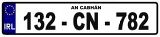
Motor vehicle index marks issued in the Cavan registration district incorporate the letters CN.
Second-level local government areas
- Municipal District of Bailieborough - Cootehill / Ceantar Bardasach Choill an Chollaigh
- Municipal District of Ballyjamesduff / Ceantar Bardasach Bhaile Shéamais Dhuibh
- Municipal District of Cavan - Belturbet / Ceantar Bardasach an Chabháin - Bhéal Tairbirt
Roads
| Route | From | To | Length |
|
|---|---|---|---|---|
| R154 | Black Bull | Crossdoney | 95.5 km | View |
| R162 | Navan | Monaghan | 75.8 km | View |
| R164 | Ballyboy | Kingscourt | 34.6 km | View |
| R165 | Blakestown | Drumnagran | 66.1 km | View |
| R178 | Dundalk | Virginia | 60.3 km | View |
| R179 | Corgarry | Corcullioncrew (border) | 23.9 km | View |
| R181 | Corclare | Tullynagrow (border) | 27.9 km | View |
| R188 | Monaghan | Cavan | 45.4 km | View |
| R190 | Annaneese | Cootehill | 14.9 km | View |
| R191 | Mullagh | Lisnasaran | 33.1 km | View |
| R192 | Shercock | Cootehill | 10.2 km | View |
| R194 | Moynalty | Lisnamuck | 54.4 km | View |
| R195 | Virginia | Castlepollard | 25.4 km | View |
| R196 | Drummanbane | Ballyjamesduff | 5.0 km | View |
| R197 | Belturbet | Corrarod | 4.3 km | View |
| R198 | Cavan | Longford | 51.3 km | View |
| R199 | Drummora Great | Ballinamore | 28.7 km | View |
| R200 | Derrynacreeve | Drumkeeran | 33.9 km | View |
| R201 | Belturbet | Drumsna | 49.8 km | View |
| R202 | Cloonturk | Drumkeeran | 38.1 km | View |
| R203 | Arvagh | Kivvy | 7.1 km | View |
| R205 | Kilnacreevy | Gortawee (border) | 13.1 km | View |
| R206 | Glangevlin | Blacklion | 14.9 km | View |
| R207 | Drumgorman | Mullaghahy | 33.9 km | View |
| R212 | Clones | Pollamore Near, Cavan | 28.1 km | View |
| R394 | Mullingar | Kilcogy | 43.7 km | View |
| R901 | Farnham Street, Cavan | College Street, Cavan | 0.87 km | View |
| R935 | Cavan | Tullycoe | 2.0 km | View |
Note that the distances stated above relate to the whole length of the routes concerned, both within and without the local road authority's boundaries
Junctions
Main Article: Cavan County Council (Junctions)
Bridges, Tunnels, and other Crossings
Main Article: Cavan County Council (Crossings)
Links
| Cavan County Council | ||||||
| ||||||
| ||||||
| ||||||
|