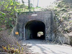
Charmouth Tunnel
Jump to navigation
Jump to search
| Charmouth Tunnel | |||||||
| Location Map ( geo) | |||||||
 | |||||||
| Location | |||||||
| Charmouth | |||||||
| County | |||||||
| Dorset | |||||||
| Opening Date | |||||||
| 1835 | |||||||
| Closure Date | |||||||
| 1991 | |||||||
| Additional Information | |||||||
| |||||||
| On road(s) | |||||||
| A35 | |||||||
The Charmouth Tunnel was a narrow S2 tunnel on the A35. It was bypassed in 1991.
The land around and including the tunnel was purchased in 2004 and the structure itself has been converted into a sports centre.
Videos
Charmouth tunnel for the last time
Charmouth tunnel in Dorset in the last few weeks before the tunnel closed
Links


