Star.pngStar grey.pngStar grey.pngStar grey.pngStar grey.png

Crooklands Interchange

From Roader's Digest: The SABRE Wiki
Jump to navigation Jump to search
Crooklands Interchange
Location Map ( geo)
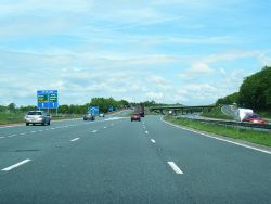
M6 northbound at Junction 36 - Geograph - 3504161.jpg
Cameraicon.png View gallery (3)
Location
Millness
County
Westmorland
Highway Authority
National Highways
Junction Type
Roundabout Interchange
Roads Joined
M6, A65, A590
Junctions related to the A590
The original junction layout shown on a 1972 OS One Inch map

Crooklands Interchange is junction 36 of the M6. It opened in 1970, though the A590 to the north-west did not open until about 1974 (and was originally A591).

For northbound traffic on the M6, this junction is the exit for Barrow, Kendal, and much of the southern Lake District. For southbound traffic, it is the exit for a main route and former trunk road to the cities of western Yorkshire. When it was first built, the M6 reduced to D2M inside the junction and there was a gantry sign in each direction. The third lane was eventually added (the bridges having been designed to allow for full-quality widening) and the gantries removed.

It is also known as Farleton Interchange.

Routes

Route To Notes

M6

The North, North Lakes, Penrith

M6

The South, Lancaster

A65

K'by Lonsdale, Skipton

A590

Barrow, Windermere, Kendal (A591)

KLM

Barrow (A590), Kendal (A6), Windermere (A591)


Crooklands Interchange
Related Pictures
View gallery (3)
M6 northbound at Junction 36 - Geograph - 3504161.jpgM6 J36 - Coppermine - 7135.JPGM6 J36 - Coppermine - 7136.JPG
Junctions on the M6
PresentM1 J19 Catthorpe • 1 Junction 1 • 2 Ansty • 3 Exhall • 3A/4 Coleshill • 4A Water Orton • 5 Castle Bromwich • 6 Gravelly Hill • 7 Great Barr • 8 Ray Hall • 9 Wednesbury • 10 Bentley • 10A Essington • 11 Laney Green • 11A Saredon • 12 Gailey • 13 Dunston • 14 Creswell • 15 Hanchurch • 16 Barthomley • 17 Sandbach • 18 Middlewich • 19 Tabley • 20 Lymm • 21 Woolston • 21A Croft • 22 Winwick • 23 Haydock Island • 24 Junction 24 • 25 Bryn • 26 Orrell • 27 Junction 27 • 28 Leyland • 29 Bamber Bridge • 30 Blacow Bridge • 31 Samlesbury • 31A Haighton • 32 Broughton • 33 Hampson Green • 34 Lune Valley • 35 Carnforth • 36 Crooklands • 37 Killington • 38 Tebay • 39 Shap • 40 Skirsgill • 41 Catterlen • 42 Golden Fleece • 43 Rosehill • 44 Kingstown • 45 Guards Mill
Former32A Broughton Roundabout • 35A Keer Level Roundabout
Unbuilt"6A" Perry Barr • "10A" Short Heath • "14A" M6 "Expressway" • "14A" M64 • "15A" M6 "Expressway" • "16A" M6 "Expressway" • "27A" Euxton • "33A" "Junction 33A"
Unenacted Extension to Glasgow"46" Gretna • "47" Kirkpatrick Fleming • "48" Eaglesfield • "49" Ecclefechan • "50" Lockerbie South • "51" Lockerbie North • "52" Johnstonebridge • "53" Beattock • "54" Elvanfoot & Crawford • "55" Abington • "56" Millbank • "57" Poniel • "58" Wellburn • "59" M74 Junction 9 • "60" Canderside Toll • "61" Larkhall • "62" Hamilton • "63" Raith • "64" Maryville • "65" Daldowie • "66" Carmyle Avenue • "67" Fullarton Road • "68" Cambuslang Road • "69" Polmadie Road • "70" Kingston
M6 TollColeshill • T1 Dunton • T2 Junction T2 • T3 Langley Mill • T4 Weeford • T5 Wall Island • T6 Brownhills  • T7 Churchbridge • T8 Wedges Mills • 11A Saredon
Junctions on the A65
Wellington Street Junction • Horsforth Roundabout • Yeadon Roundabout • White Cross • Menston Roundabout • Burley Bypass Roundabout • Addingham Bypass Roundabout • Skibeden Fork • Haw Park Roundabout • The Bailey Junction • Grassington Road Roundabout • Gargrave Road Roundabout • Thornton in Lonsdale Fork • Crooklands Interchange • Burton Road Roundabout


SABRE - The Society for All British and Irish Road Enthusiasts
Discuss - Digest - Discover - Help