Derry
| Derry / Londonderry Doire | |||
| Location Map ( geo) | |||
 | |||
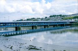
| The Craigavon Bridge, overlooking Derry city | |||
| |||
| County | |||
| Londonderry | |||
| Forward Destination on | |||
| A2, A5, A6, A514, A515, (N13) | |||
| Next Primary Destinations | |||
| Antrim • Coleraine • Strabane | |||
| Next Terminal & Intermediate Destinations | |||
| Letterkenny | |||
For the County, see County Londonderry.
Derry or Londonderry is the second largest city in Northern Ireland, and consequently is an important hub of several major routes.
The proximity to the border with the Republic, combined with the city being at the other end of Northern Ireland to Belfast, means that access has been generally under-invested. Both of the main roads inside Northern Ireland (the A5 from Enniskillen and the A6 from Belfast) have been earmarked for improvement. The A2 coastal route starts on the border near Derry, though it is only a main road as far as Limavady.
The A515 Foyle Bridge, which opened in 1984, is a major local architectural achievement that allows through traffic to avoid the city centre. However, it is intermittently closed due to high winds. From 2003 - 2005, the bridge underwent major refurbishment that allowed it to cater for HGVs better.
Name
The city's name has been a contentious subject between nationalists (who prefer Derry) and unionists (who prefer Londonderry) since the outbreak of The Troubles in the 1960s. Not surprisingly, this is reflected in road signs.
Northern Ireland consistently signs the city as "Londonderry" in English only, though it is not uncommon to see these vandalised by blacking or spray painting out "London". Conversely, the Republic of Ireland sign the city consistently as "Derry", including the Irish "Doire". Someone travelling along the N2 in the Republic in the direction of Derry will see signs from the latter being replaced by those for the former at the point the border is crossed, though on the N13, the border is close enough to the city itself that "Derry" is replaced merely by "City Centre".
Convention on the internet has tended towards using "Derry" for the city and "Londonderry" for the county. Both OpenStreetMap and Google Maps refer to the city as "Londonderry / Derry". Older maps, including Bartholomew Half Inch of Ireland, the Irish War Office, and OSNI consistently use "Londonderry", even for maps of the entire island of Ireland. Surprisingly, Ordnance Survey Ireland mapping consistently refers to Londonderry up until the 1970s, with the switch to using Derry being completed by the mid-1980s; though occasionally the word Londonderry is split across two lines.
Routes
| Route | To | Notes |
| Letterkenny, Buncrana | becomes N13 at border | |
| Coleraine, Limavady, Maydown, Campsie, Lisahally, Eglinton, Airport | ||
| Omagh, Strabane | becomes N2 at border | |
| Belfast, Antrim, Larne, Dungiven, Claudy | ||
| forms an eastern bypass | ||
| forms a northern bypass | ||
| Srath an Urlair / STRANOLAR, Leitir Ceanainn / LETTERKENNY | via A2 | |
| Greencastle, Moville, Culmore | becomes R238 at border | |
| Lifford, St.Johnstown, Raphoe, Carrigans | ||
| Donemana | ||
| Letterkenny | ||
| Northland Road | ||
| Templemore, Sports Complex | ||
| Brandwell | ||
| Glenowen, Hazelbank, Foyle Springs | ||
| An Carraigin/CARRIGANS | ||
| An Baile Nua/NEWTOWNCUNNINGHAM (N13) | ||
| Bun Cranncha/BUNCRANA | ||
| Bun an Phobail/MOVILLE | ||
| Omagh, Strabane | unsigned, uses A5 | |
| Coleraine, Limavady, Maydown, Campsie, Lisahally, Eglinton, Airport | unsigned, uses A2 | |
| Belfast, Antrim, Larne, Dungiven, Claudy | unsigned, uses A6 | |
| unsigned, uses A514 and A515 | ||
| Belfast, Antrim, Larne, Dungiven, Claudy | unsigned, uses A6 | |
| Belfast, Coleraine (M2), Limavady |
Links


