Dunheved Bridge
| Dunheved Bridge | |||
| Location Map ( geo) | |||
 | |||
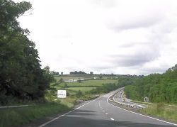
| Approaching Dunheved Bridge from the Devon side. | |||
| |||
| From: | Okehampton | ||
| To: | Bodmin | ||
| Location | |||
| Launceston Bypass | |||
| County | |||
| Devon • Cornwall | |||
| Highway Authority | |||
| National Highways | |||
| On road(s) | |||
| A30 | |||
| Crossings related to the A30 | |||
Dunheved Bridge, also known as Launceston Bypass Bridge, crosses the River Tamar to the east of Launceston on the A30 and forms part of the dual carriageway bypass of Launceston. It avoids the much older Polson Bridge, which now lies on the A388 (the original A30) and is named after the original name of the town, Dunheved.
Two structures have been built on the site. The original bridge opened with the Launceston Bypass in 1978 and was a steel reinforced concrete design. It was originally going to be called the Tamar Bridge, but that name was already taken by the famous suspension bridge between Plymouth and Saltash.
The newer bridge was a replacement of the original, and was built in two stages from April 2006 to March 2007.
Replacement
In 2005, the original bridge was showing signs of 'Concrete Cancer' and it was decided that it should be covered in a Glass Reinforced Plastic (GRP) shell to prevent further damage, which would extend the life of the bridge for 30-40 years. However, the winning contractors created a design that was marginally more expensive, but replaced the bridge decks entirely, meaning a much longer lasting design.
The bridge replacement was very clever. First, the westbound bridge was built on temporary steel pillars next to the existing bridge. Once it was completed, the westbound traffic was moved onto the new bridge, and eastbound traffic was moved on the old westbound bridge. This enabled the original eastbound bridge to be demolished and for the new eastbound side to be built in place. Once this happened, eastbound traffic moved onto the new bridge and the westbound bridge was demolished.
The clever bit was that once that had happened, traffic was put into a contraflow arrangement for two weeks so that the new westbound bridge could be slid into position using special hydraulic rams and sledges. This whole process significantly reduced delays caused by the contraflow as it was only need for those two weeks, instead of the full duration of the works when replacing bridges traditionally.
This was a great benefit to the scheme, especially as the delays on the road for long distance traffic were already numerous due to Merrymeet roundabout being replaced and the Bodmin - Indian Queens dualling scheme still in progress at the same time. Some Highways Agency officials at the time commented that the M25 roadworks being carried out at around the same time had received significantly less complaints about delays than the Merrymeet works, and so reducing congestion on the route was a key objective while the scheme was being carried out.
Awards
The Dunheved Bridge Replacement scheme was Nominated for the Prime Minister's Better Public Building Awards in 2007, for the innovative way that it avoided congestion on the route.
Links
| Dunheved Bridge | ||||||||||
| ||||||||||
|

