Falconwood
| Falconwood | |||
| Location Map ( geo) | |||
 | |||
| A2 at Falconwood | |||
| |||
| Location | |||
| Falconwood | |||
| County | |||
| Kent | |||
| Highway Authority | |||
| Transport for London | |||
| Junction Type | |||
| Half-diamond | |||
| Roads Joined | |||
| A2, Unclassified | |||
Falconwood is the junction on the A2 where the 1988 Rochester Way Relief Road has its eastern end on Rochester Way. The junction is a half diamond, with the A2 losing/gaining a lane to/from the sliproads, it is one of the A2's congestion black spots. Before the coming of TfL this was also the place where the A2 became NSL from a 50 mph limit. Now it 50 all the way to the Kent border.
A key reason for the lane drop is that this was to be where the link road from the East London River Crossing was to end. This, like the earlier plans for Ringway 2 through the area, were stopped due to the environmental impact of the route through Oxleas Wood (just to the north of the junction).
Routes
| Route | To | Notes |
| Central London, Lewisham, Blackwall Tunnel (A102) | ||
| Dover, Bexleyheath, Dartford Crossing (M25) | ||
| Blackfen (A210), Eltham Cemetery & Crematorium | Riefield Road. No access from A2 | |
| Welling, Falconwood | Rochester Way. Signed as 'Local traffic' from the A2 | |
| Central London, Lewisham, Blackwall Tunnel (A102(M)) | ||
| (A13, M11, M12), Barking, Woolwich, Thamesmead, Welling | ||
| (A20, A21, M23), Bromley, Beckenham, Croydon | ||
| (A13, M11, M12), Barking, Woolwich, Thamesmead, Welling |
Strip Maps
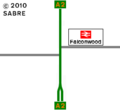
The interchange as it was in 1972.
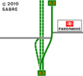
The interchange as it was in 1986.
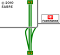
The interchange as it is now.


