 | |  |
| | Description: | Closed Northern Avenue Bridge, Boston.
Built 1908, closed to vehicles in 1999 and closed to pedestrians | | Location: | 42.35513, -71.05022 | | Road: | | | Date: | 11 09 2017 | | Photographer: | C2r | | Source: | |
|
|
| |
 | |  |
File history
Click on a date/time to view the file as it appeared at that time.
| Date/Time | Thumbnail | Dimensions | User | Comment |
|---|
| current | 21:46, 11 August 2018 | 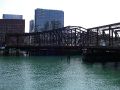 | 3,072 × 2,304 (1.48 MB) | C2r (talk | contribs) | Closed Northern Avenue Bridge, Boston. Built 1908, closed to vehicles in 1999 and closed to pedestrians |
File usage
There are no pages that use this file.
This file contains additional information, probably added from the digital camera or scanner used to create or digitise it.
If the file has been modified from its original state, some details may not fully reflect the modified file.

