 | |  |
| | Description: | C150 Herringswell Road, Cambridgeshire
this image shows pretty much the entire length of the classified road in Cambridgeshire. | | Location: | 52.2848443, 0.502701 | | Road: | C150 (Cambridgeshire) | | Date: | 16 09 2018 | | Photographer: | C2r | | Source: | |
|
|
| |
 | |  |
File history
Click on a date/time to view the file as it appeared at that time.
| Date/Time | Thumbnail | Dimensions | User | Comment |
|---|
| current | 18:29, 28 September 2018 | 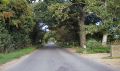 | 2,909 × 1,729 (1.06 MB) | C2r (talk | contribs) | C150 Herringswell Road Cambridgeshire |
File usage
The following 2 pages use this file:
This file contains additional information, probably added from the digital camera or scanner used to create or digitise it.
If the file has been modified from its original state, some details may not fully reflect the modified file.

