File:3-6 Cleveland Place East, Bath - Geograph - 3831438.jpg

From Roader's Digest: The SABRE Wiki
Jump to navigation Jump to search

3-6_Cleveland_Place_East,_Bath_-_Geograph_-_3831438.jpg(640 × 447 pixels, file size: 155 KB, MIME type: image/jpeg)

Y topleft.gifY topright.gif
Description:
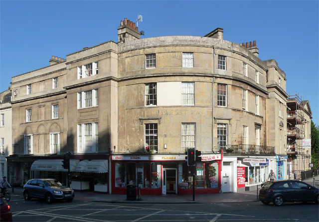
3-6 Cleveland Place East, Bath Part of a set-piece approach to Cleveland Bridge ([[[3831109]]]), and Bathwick beyond, by Henry Goodridge, c1827-30. Curved section flanked by projecting square bays with tripartite windows. Grade II listed.
Location:51.390068, -2.356511
Road:A36, A4
Date:25 05 2012
Photographer:(c) Copyright Stephen Richards and licensed for reuse under this Creative Commons Licence
Source:Geograph

Map

Y btmleft.gifY btmright.gif

Galleries  | A36 | A4 | Cleveland Place | Traffic Signals

File history

Click on a date/time to view the file as it appeared at that time.

Date/TimeThumbnailDimensionsUserComment
current14:29, 11 August 2016Thumbnail for version as of 14:29, 11 August 2016640 × 447 (155 KB)Rileyrob (talk | contribs)'''3-6 Cleveland Place East, Bath''' Part of a set-piece approach to Cleveland Bridge ([3831109]), and Bathwick beyond, by Henry Goodridge, c1827-30. Curved section flanked by projecting square bays with tripartite windows. Grade II listed.

The following 2 pages use this file:

Metadata

SABRE - The Society for All British and Irish Road Enthusiasts
Discuss - Digest - Discover - Help