File:A282 Strip Map 2013.png
Jump to navigation
Jump to search

Size of this preview: 266 × 599 pixels. Other resolution: 437 × 984 pixels.
Original file (437 × 984 pixels, file size: 64 KB, MIME type: image/png)
| |||||||||||||||||||||||||
|
Galleries | A282 | Strip Maps | ||
File history
Click on a date/time to view the file as it appeared at that time.
| Date/Time | Thumbnail | Dimensions | User | Comment | |
|---|---|---|---|---|---|
| current | 20:14, 6 September 2015 | | 437 × 984 (64 KB) | Abeaton (talk | contribs) | Minor Fixes |
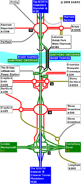
| 20:12, 6 September 2015 |  | 437 × 984 (63 KB) | Abeaton (talk | contribs) | The A282 as it was in 2013. |
File usage
The following page uses this file: