File:A653, Parkfield Street Bridge, Leeds (C) Richard Kay - Geograph - 1662656.jpg

From Roader's Digest: The SABRE Wiki
Jump to navigation Jump to search

A653,_Parkfield_Street_Bridge,_Leeds_(C)_Richard_Kay_-_Geograph_-_1662656.jpg(640 × 425 pixels, file size: 87 KB, MIME type: image/jpeg)

Y topleft.gifY topright.gif
Description:
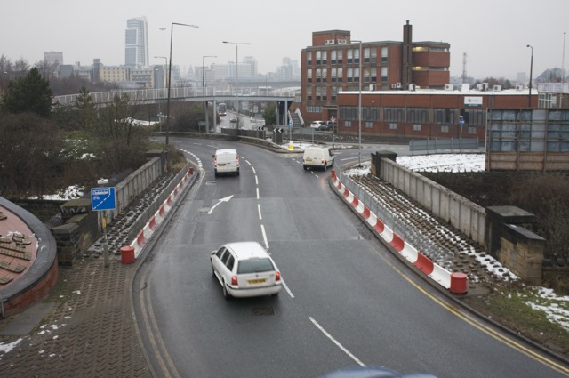
A653, Parkfield Street Bridge, Leeds (C) Richard Kay
Here, Dewsbury Road becomes Parkfield Street on its way into Leeds, probably due to highway re-alignments during the construction of the M621 (then M1) in 1969. The bridge is an original railway bridge now owned by Railtrack. The structure under the verges has insufficient capacity to carry vehicle wheel loads, and therefore has been protected by the red and white steel barriers.
Location:53.784987, -1.544194
Road:A653
Date:13 01 2010
Photographer:Richard Kay and licensed for reuse under this Creative Commons Licence
Source:Geograph

Map

Y btmleft.gifY btmright.gif

Galleries  | A653 | Holbeck Interchange | Leeds

File history

Click on a date/time to view the file as it appeared at that time.

Date/TimeThumbnailDimensionsUserComment
current15:08, 15 March 2014Thumbnail for version as of 15:08, 15 March 2014640 × 425 (87 KB)Vlad (talk | contribs)'''A653, Parkfield Street Bridge, Leeds (C) Richard Kay '''<br/>Here, Dewsbury Road becomes Parkfield Street on its way into Leeds, probably due to highway re-alignments during the construction of the M621 (then M1) in 1969. The bridge is an original r...

The following 3 pages use this file:

Metadata

SABRE - The Society for All British and Irish Road Enthusiasts
Discuss - Digest - Discover - Help