File:A658 at Pool Bridge - Geograph - 708541.jpg

From Roader's Digest: The SABRE Wiki
Jump to navigation Jump to search

A658_at_Pool_Bridge_-_Geograph_-_708541.jpg(640 × 427 pixels, file size: 82 KB, MIME type: image/jpeg)

Y topleft.gifY topright.gif
Description:
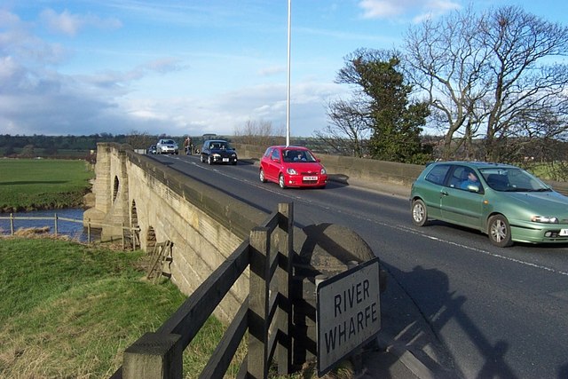
A658 at Pool Bridge
Pool Bridge is a 'Boundary Bridge', that is it straddles the geographical boundary between Leeds City and North Yorkshire. The boundary runs along the centreline of the River Wharfe. By agreement, boundary bridges and the highway over them are maintained by one of the two adjoining Highway Authorities, in this case the bridge and its highway are maintained by Leeds. The boundary signs for North Yorkshire are out of sight on the north side of the River Wharfe
Location:53.905092, -1.630407
Road:A658
Date:27 02 2008
Photographer:� Copyright Richard Kay and licensed for reuse under this Creative Commons Licence
Source:Geograph

Map

Y btmleft.gifY btmright.gif

Galleries  | A658 | Pool Bridge | Pictures from Geograph

File history

Click on a date/time to view the file as it appeared at that time.

Date/TimeThumbnailDimensionsUserComment
current18:47, 5 April 2010Thumbnail for version as of 18:47, 5 April 2010640 × 427 (82 KB)Bob@romiley1 (talk | contribs)'''A658 at Pool Bridge'''<br/>Pool Bridge is a 'Boundary Bridge', that is it straddles the geographical boundary between Leeds City and North Yorkshire. The boundary runs along the centreline of the River Wharfe. By agreement, boundary bridges and the hi

The following 2 pages use this file:

Metadata

SABRE - The Society for All British and Irish Road Enthusiasts
Discuss - Digest - Discover - Help