File:A74(M) J15.PNG
Jump to navigation
Jump to search

No higher resolution available.
A74(M)_J15.PNG (259 × 237 pixels, file size: 9 KB, MIME type: image/png)
| ||||||||||||||
|
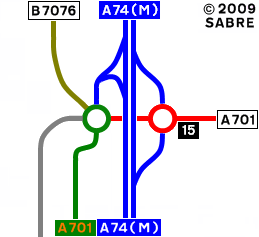
Galleries | A74(M) | Beattock Interchange | Strip Maps | ||
File history
Click on a date/time to view the file as it appeared at that time.
| Date/Time | Thumbnail | Dimensions | User | Comment | |
|---|---|---|---|---|---|
| current | 15:49, 7 September 2009 | | 259 × 237 (9 KB) | Abeaton (talk | contribs) | {{Information |description = |day = |month = |year = |photographer = |source = |road = |lat = |lng = }} |
File usage
The following 2 pages use this file:
_J15.PNG&oldid=300956)