
No higher resolution available.
 | |  |
| | Description: | The A859 looking north from the start of the path up Clisham, the highest point in the Western Isles. | | Location: | 57.951171, -6.778082 | | Road: | A859 | | Date: | 8 9 2013 | | Photographer: | | | Source: | |
|
|
| |
 | |  |
File history
Click on a date/time to view the file as it appeared at that time.
| Date/Time | Thumbnail | Dimensions | User | Comment |
|---|
| current | 08:40, 16 September 2013 | 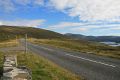 | 640 × 427 (136 KB) | Rileyrob (talk | contribs) | The A859 looking north from the start of the path up Clisham, the highest point in the Western Isles. |
File usage
The following page uses this file:
This file contains additional information, probably added from the digital camera or scanner used to create or digitise it.
If the file has been modified from its original state, some details may not fully reflect the modified file.
