 | |  |
| | Description: | The C27 road heading north-westwards before dropping down into Glen Prosen. The blunt cone of Mayer in the distance stands at the head of the glen. | | Location: | 56.743339, -3.053272 | | Road: | C27 (Angus) | | Date: | 02 10 2017 | | Photographer: | Scott Cormie | | Source: | |
|
|
| |
 | |  |
File history
Click on a date/time to view the file as it appeared at that time.
| Date/Time | Thumbnail | Dimensions | User | Comment |
|---|
| current | 16:05, 30 December 2018 | 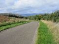 | 5,184 × 3,888 (1.04 MB) | Scotti (talk | contribs) | The C27 road heading north-westwards before dropping down into Glen Prosen. The blunt cone of Mayer in the distance stands at the head of the glen. |
File usage
The following page uses this file:
This file contains additional information, probably added from the digital camera or scanner used to create or digitise it.
If the file has been modified from its original state, some details may not fully reflect the modified file.

