File:Acton Low Traffic Neighbourhood, Acacia Road closure - Geograph - 6738184.jpg

From Roader's Digest: The SABRE Wiki
Jump to navigation Jump to search

Acton_Low_Traffic_Neighbourhood,_Acacia_Road_closure_-_Geograph_-_6738184.jpg(640 × 480 pixels, file size: 107 KB, MIME type: image/jpeg)

Y topleft.gifY topright.gif
Description:
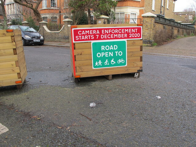
Acton Low Traffic Neighbourhood, Acacia Road closure The area behind the photographer is accessible from Churchfield Road, that in front from Horn Lane. The signs here are more friendly than at other closures, the sign show the road open to pedestrians, unpowered scooters, wheel chairs and bicycles. It also shows camera enforcement which will have automatic number plate recognition (ANPR).
Location:51.513155, -0.268350
Road:
Date:18 01 2021
Photographer:(c) Copyright David Hawgood and licensed for reuse under this Creative Commons Licence
Source:Geograph

Map

Y btmleft.gifY btmright.gif

Galleries  | Low Traffic Neighbourhood | Acton

File history

Click on a date/time to view the file as it appeared at that time.

Date/TimeThumbnailDimensionsUserComment
current11:33, 24 February 2021Thumbnail for version as of 11:33, 24 February 2021640 × 480 (107 KB)C2r (talk | contribs)'''Acton Low Traffic Neighbourhood, Acacia Road closure''' The area behind the photographer is accessible from Churchfield Road, that in front from Horn Lane. The signs here are more friendly than at other closures, the sign show the road open to pedestrians, unpowered scooters, wheel chairs and bicycles. It also shows camera enforcement which will have automatic number plate recognition (ANPR).

The following 2 pages use this file:

SABRE - The Society for All British and Irish Road Enthusiasts
Discuss - Digest - Discover - Help