File:Aust-1953.jpg
Jump to navigation
Jump to search

No higher resolution available.
Aust-1953.jpg (400 × 364 pixels, file size: 53 KB, MIME type: image/jpeg)
| |||||||||||||||||||||||||
|
Galleries | M4 | M48 | B4055 | Severn Bridge | B4228 | B4461 | OS One Inch | Aust Ferry | ||
File history
Click on a date/time to view the file as it appeared at that time.
| Date/Time | Thumbnail | Dimensions | User | Comment | |
|---|---|---|---|---|---|
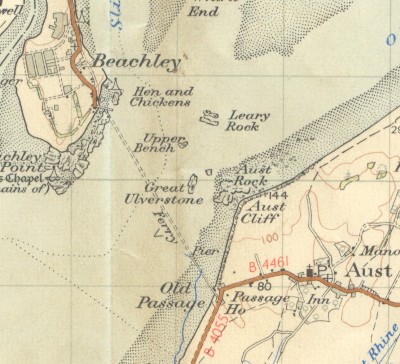
| current | 18:55, 28 November 2009 | | 400 × 364 (53 KB) | Rileyrob (talk | contribs) | {{Information |description = The Aust Ferry in 1953. |day = |month = |year = 1953 |photographer = |source = OS Seventh Series Sheet 155 |road = M4 |road2 = M48 |road3 = B4055 |lat = 51.60565 |
| 18:48, 28 November 2009 |  | 709 × 645 (133 KB) | Rileyrob (talk | contribs) | {{Information |description = The Aust Ferry in 1953. |day = |month = |year = 1953 |photographer = |source = OS Seventh Series Sheet 155 |road = M4 |road2 = M48 |road3 = B4055 |lat = 51.60565 |
File usage
The following 4 pages use this file: