File:Brother Edmund Ignatius Rice Bridge (plaque) - Geograph - 5821143.jpg
Jump to navigation
Jump to search

No higher resolution available.
Brother_Edmund_Ignatius_Rice_Bridge_(plaque)_-_Geograph_-_5821143.jpg (640 × 409 pixels, file size: 151 KB, MIME type: image/jpeg)
| |||||||||||||||||||||||||
|
Galleries | N25 | Waterford | Brother Edmund-Ignatius Rice Bridge | ||
File history
Click on a date/time to view the file as it appeared at that time.
| Date/Time | Thumbnail | Dimensions | User | Comment | |
|---|---|---|---|---|---|
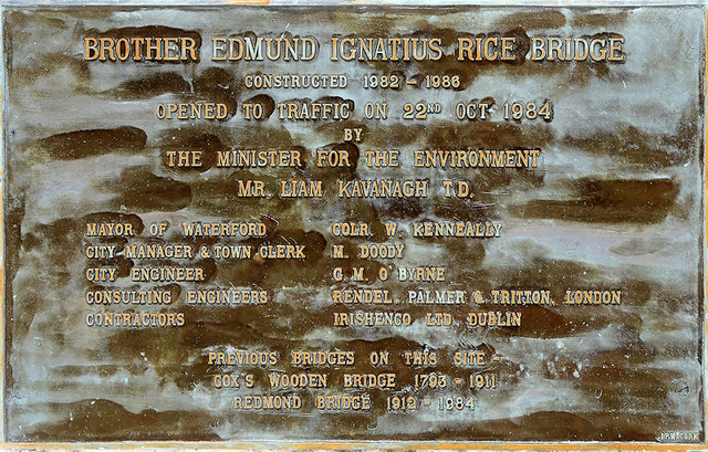
| current | 11:58, 29 April 2020 | | 640 × 409 (151 KB) | Ritchie333 (talk | contribs) | '''Brother Edmund Ignatius Rice Bridge (plaque)''' The Rice Bridge crosses the River Suir on the north side of the city centre at Waterford. It was constructed in stages between 1982 and 1986 after the previous bridge was deemed unsafe. It is named after Brother Edmund Ignatius Rice (and is sometimes called the Edmund Rice Bridge or Brother Edmund Ignatius Rice Bridge). See [5821137] |
File usage
The following 2 pages use this file:
_-_Geograph_-_5821143.jpg&oldid=625529)