File:Grosvenor Bridge Abutment - Geograph - 290847.jpg

From Roader's Digest: The SABRE Wiki
Jump to navigation Jump to search

Original file(480 × 640 pixels, file size: 208 KB, MIME type: image/jpeg)

Y topleft.gifY topright.gif
Description:
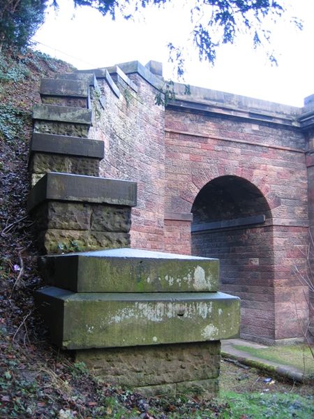
Grosvenor Bridge Abutment
The south east bridge abutment for Chester's Grosvenor Bridge, built of limestone but capped and faced with sandstone. The side arch allows an access track and a public footpath to pass through to the Dingle. The A483 Wrexham Road passes over the bridge (and the River Dee) into Chester.
Location:53.182321, -2.896283
Road:A483
Date:06 12 2006
Photographer:� Copyright John S Turner and licensed for reuse under this Creative Commons Licence
Source:Geograph

Map

Y btmleft.gifY btmright.gif

Galleries  | A483 | Chester | Grosvenor Bridge

File history

Click on a date/time to view the file as it appeared at that time.

Date/TimeThumbnailDimensionsUserComment
current12:23, 7 August 2010Thumbnail for version as of 12:23, 7 August 2010480 × 640 (208 KB)Bob@romiley1 (talk | contribs)'''Grosvenor Bridge Abutment'''<br/>The south east bridge abutment for Chester's Grosvenor Bridge, built of limestone but capped and faced with sandstone. The side arch allows an access track and a public footpath to pass through to the Dingle. The A483 W

The following 3 pages use this file:

Metadata

SABRE - The Society for All British and Irish Road Enthusiasts
Discuss - Digest - Discover - Help