 | |  |
| | Description: | Just outside Tewkesbury Mill along Mill Street and St Mary's Road. Flooding marker used to measure the water levels whenever the area floods. | | Location: | 51.991265, -2.162538 | | Road: | | | Date: | 10 06 2021 | | Photographer: | Luca Nunnerley | | Source: | |
|
|
| |
 | |  |
File history
Click on a date/time to view the file as it appeared at that time.
| Date/Time | Thumbnail | Dimensions | User | Comment |
|---|
| current | 20:03, 11 June 2021 | 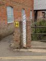 | 1,449 × 1,932 (704 KB) | Luca nunnerley (talk | contribs) | IMG_1011.JPG Flooding Measurement.jpg |
File usage
There are no pages that use this file.
This file contains additional information, probably added from the digital camera or scanner used to create or digitise it.
If the file has been modified from its original state, some details may not fully reflect the modified file.

