File:Kilcarn Bridge, Navan - Geograph - 491513.jpg

From Roader's Digest: The SABRE Wiki
Jump to navigation Jump to search

Kilcarn_Bridge,_Navan_-_Geograph_-_491513.jpg(640 × 480 pixels, file size: 149 KB, MIME type: image/jpeg)

Y topleft.gifY topright.gif
Description:
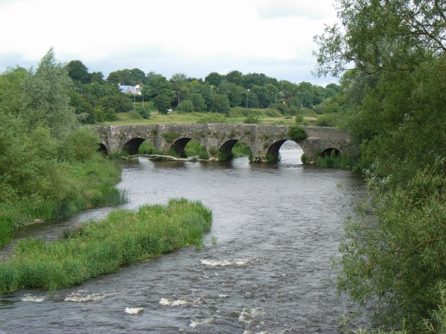
Kilcarn Bridge, Navan Located on the Boyne 2km upstream from Navan, this bridge originally dates from around 1600. It was on the main road from Navan to Dublin until 1977, when a new bridge was constructed (from which this photo was taken). There have been many 'Save Kilcarn Bridge' campaigns over the years and, judging from the state of the central cutwaters, it looks like another would be in order pretty soon. Incidentally, Kilcarn is also sometimes spelt 'Kilcarne' or 'Kilcairn'.
Location:53.631768, -6.661876
Road:N3
Date:08 07 2007
Photographer:(c) Copyright JP and licensed for reuse under this Creative Commons Licence
Source:Geograph

Map

Y btmleft.gifY btmright.gif

Galleries  | N3 | Kilcarn Bridge | Pictures from Geograph

File history

Click on a date/time to view the file as it appeared at that time.

Date/TimeThumbnailDimensionsUserComment
current22:56, 19 August 2019Thumbnail for version as of 22:56, 19 August 2019640 × 480 (149 KB)C2r (talk | contribs)'''Kilcarn Bridge, Navan''' Located on the Boyne 2km upstream from Navan, this bridge originally dates from around 1600. It was on the main road from Navan to Dublin until 1977, when a new bridge was constructed (from which this photo was taken). There...

The following 2 pages use this file:

SABRE - The Society for All British and Irish Road Enthusiasts
Discuss - Digest - Discover - Help