File:Lechlade Town Bridge - Geograph - 576804.jpg

From Roader's Digest: The SABRE Wiki
Jump to navigation Jump to search

Lechlade_Town_Bridge_-_Geograph_-_576804.jpg(640 × 469 pixels, file size: 99 KB, MIME type: image/jpeg)

Y topleft.gifY topright.gif
Description:
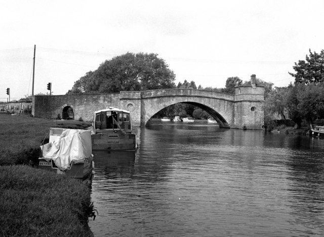
Lechlade Town Bridge
A Grade II listed structure. It was built in 1792 as part of a turnpike road from Burford to Swindon, which has now become part of the A361. It was a toll bridge until 1839, pedestrians paying one halfpenny, so it earned he nickname of 'The Ha'penny Bridge'. The structure at the left hand end would have been the tollhouse, at the top, and probably the lower part would have found use as a jail. At least the prisoners would have had a pleasant view through the small barred window!
Location:51.692052, -1.693251
Road:A361, Halfpenny Bridge
Date:15 06 1980
Photographer:� Copyright Dr Neil Clifton and licensed for reuse under this Creative Commons Licence
Source:Geograph

Map

Y btmleft.gifY btmright.gif

Galleries  | A361 | Halfpenny Bridge

File history

Click on a date/time to view the file as it appeared at that time.

Date/TimeThumbnailDimensionsUserComment
current16:52, 24 May 2010Thumbnail for version as of 16:52, 24 May 2010640 × 469 (99 KB)Bob@romiley1 (talk | contribs)'''Lechlade Town Bridge'''<br/>A Grade II listed structure. It was built in 1792 as part of a turnpike road from Burford to Swindon, which has now become part of the A391. It was a toll bridge until 1839, pedestrians paying one halfpenny, so it earned h

The following page uses this file:

Metadata

SABRE - The Society for All British and Irish Road Enthusiasts
Discuss - Digest - Discover - Help