File:Littlebrook Interchange 2011.PNG
Jump to navigation
Jump to search

No higher resolution available.
Littlebrook_Interchange_2011.PNG (258 × 237 pixels, file size: 10 KB, MIME type: image/png)
| |||||||||||||||||||||||||
|
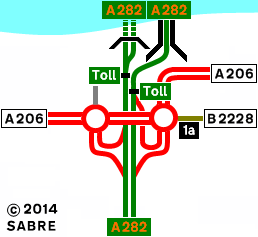
Galleries | A282 | A206 | B2228 | Dartford | Littlebrook Interchange | Strip Maps | ||
File history
Click on a date/time to view the file as it appeared at that time.
| Date/Time | Thumbnail | Dimensions | User | Comment | |
|---|---|---|---|---|---|
| current | 20:41, 11 July 2014 | | 258 × 237 (10 KB) | Abeaton (talk | contribs) | New Version |
| 21:03, 1 March 2011 |  | 258 × 237 (13 KB) | Abeaton (talk | contribs) | Littlebrook Interchange as it is today. |
File usage
The following 3 pages use this file: