File:London Road, Spalding (1) (C) Stephen Richards - Geograph - 1848353.jpg

From Roader's Digest: The SABRE Wiki
Jump to navigation Jump to search

London_Road,_Spalding_(1)_(C)_Stephen_Richards_-_Geograph_-_1848353.jpg(640 × 458 pixels, file size: 214 KB, MIME type: image/jpeg)

Y topleft.gifY topright.gif
Description:
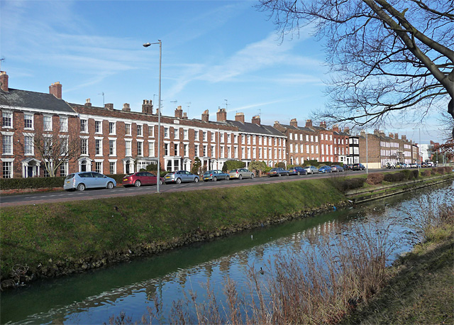
London Road, Spalding (1) (C) Stephen Richards
A fine display of Georgian houses facing the River Welland. The group on the left is Welland Terrace, possibly by John Cunnington in 1813. The others range from the mid-C18th to early-C19th, and all are either Grade II or Grade II* listed.
Spalding is an attractive town which makes unusually good use of its river. Handsome buildings line either side facing each other across the river.
Location:52.784492, -0.151283
Road:B1172 (Spalding)
Date:09 05 2010
Photographer:Stephen Richards and licensed for reuse under this Creative Commons Licence
Source:Geograph

Map

Y btmleft.gifY btmright.gif

Galleries  | B1172 (Spalding)

File history

Click on a date/time to view the file as it appeared at that time.

Date/TimeThumbnailDimensionsUserComment
current19:28, 24 May 2015Thumbnail for version as of 19:28, 24 May 2015640 × 458 (214 KB)Vlad (talk | contribs)'''London Road, Spalding (1) (C) Stephen Richards '''<br/>A fine display of Georgian houses facing the River Welland. The group on the left is Welland Terrace, possibly by John Cunnington in 1813. The others range from the mid-C18th to early-C19th, and...

The following page uses this file:

Metadata

SABRE - The Society for All British and Irish Road Enthusiasts
Discuss - Digest - Discover - Help