File:M25 Strip Map 1986 I.png
Jump to navigation
Jump to search

Size of this PNG preview of this PNG file: 143 × 599 pixels.
Original file (437 × 1,829 pixels, file size: 2.29 MB, MIME type: image/x-ms-bmp)
| |||||||||||||||||||||||||
|
Galleries | M25 | M25 History | ||
File history
Click on a date/time to view the file as it appeared at that time.
| Date/Time | Thumbnail | Dimensions | User | Comment | |
|---|---|---|---|---|---|
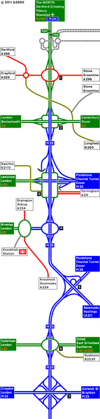
| current | 11:46, 29 October 2011 | 437 × 1,829 (2.29 MB) | Abeaton (talk | contribs) | This is the M25 upon full opening on 29th October 1986. This section is between J1-7 |
File usage
There are no pages that use this file.