File:M25 slip road approaches Hunton Bridge roundabout - Geograph - 3005583.jpg

From Roader's Digest: The SABRE Wiki
Jump to navigation Jump to search

M25_slip_road_approaches_Hunton_Bridge_roundabout_-_Geograph_-_3005583.jpg(640 × 480 pixels, file size: 59 KB, MIME type: image/jpeg)

Y topleft.gifY topright.gif
Description:
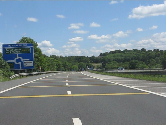
M25 slip road approaches Hunton Bridge roundabout The blanked out third lane on the right is a legacy of the slip road acting as the temporary main line of the M25 between 1976 and 1986, with major traffic flows at the roundabout onto the A405 and A41.
Location:51.684899, -0.427587
Road:M25
Date:19 06 2012
Photographer:(c) Copyright Peter Whatley and licensed for reuse under this Creative Commons Licence
Source:Geograph

Map

Y btmleft.gifY btmright.gif

Galleries  | M25 | Hunton Bridge

File history

Click on a date/time to view the file as it appeared at that time.

Date/TimeThumbnailDimensionsUserComment
current16:12, 13 June 2016Thumbnail for version as of 16:12, 13 June 2016640 × 480 (59 KB)Jeni (talk | contribs)'''M25 slip road approaches Hunton Bridge roundabout''' The blanked out third lane on the right is a legacy of the slip road acting as the temporary main line of the M25 between 1976 and 1986, with major traffic flows at the roundabout onto the A405 an...

Metadata

SABRE - The Society for All British and Irish Road Enthusiasts
Discuss - Digest - Discover - Help