File:Patcham Interchange.PNG
Jump to navigation
Jump to search

No higher resolution available.
Patcham_Interchange.PNG (300 × 240 pixels, file size: 4 KB, MIME type: image/png)
| |||||||||||||||||||||||||
|
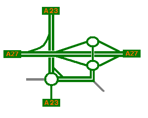
Galleries | A23 | A27 | Patcham Interchange | ||
File history
Click on a date/time to view the file as it appeared at that time.
| Date/Time | Thumbnail | Dimensions | User | Comment | |
|---|---|---|---|---|---|
| current | 18:43, 30 November 2009 | | 300 × 240 (4 KB) | Ajk1982 (talk | contribs) | {{Information |description = Patcham Interchange Strip Map |day = |month = |year = |photographer = AJK1982 |source = |road = A23 |road2 = A27 |road3 = |lat = 50.8683511 |lng = -0. |
File usage
The following 3 pages use this file: