File:Penmaenpool Bridge (C) Nigel Brown - Geograph - 3823557.jpg

From Roader's Digest: The SABRE Wiki
Jump to navigation Jump to search

Penmaenpool_Bridge_(C)_Nigel_Brown_-_Geograph_-_3823557.jpg(640 × 426 pixels, file size: 160 KB, MIME type: image/jpeg)

Y topleft.gifY topright.gif
Description:
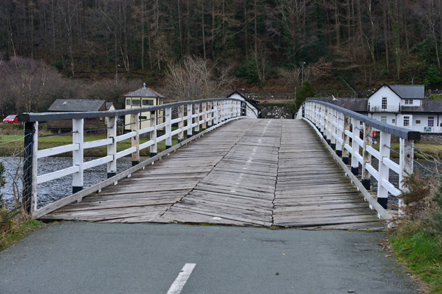
Penmaenpool Bridge (C) Nigel Brown
A landmark wooden toll bridge which provides a useful crossing of the Afon Mawddach. On the other side of the bridge, the signal box of the one-time railway is now used as a nature reserve visitor centre, while the house on the right was the station, mainly the station-master's house, now used as a private residence. The actual station platforms and waiting-room were next to the signal box.
Location:52.748930, -3.935730
Road:Ffordd Arfordirol
Date:23 01 2014
Photographer:Nigel Brown and licensed for reuse under this Creative Commons Licence
Source:Geograph

Map

Y btmleft.gifY btmright.gif

Galleries  | Ffordd Arfordirol | Penmaenpool Bridge

File history

Click on a date/time to view the file as it appeared at that time.

Date/TimeThumbnailDimensionsUserComment
current11:33, 5 April 2014Thumbnail for version as of 11:33, 5 April 2014640 × 426 (160 KB)Ritchie333 (talk | contribs)'''Penmaenpool Bridge (C) Nigel Brown '''<br/>A landmark wooden toll bridge which provides a useful crossing of the Afon Mawddach. On the other side of the bridge, the signal box of the one-time railway is now used as a nature reserve visitor centre, w...

The following page uses this file:

Metadata

SABRE - The Society for All British and Irish Road Enthusiasts
Discuss - Digest - Discover - Help