File:Scans from Oldhams 'NEW' Road Atlas (1963) 1. - Coppermine - 243.jpg
Jump to navigation
Jump to search

No higher resolution available.
Scans_from_Oldhams_'NEW'_Road_Atlas_(1963)_1._-_Coppermine_-_243.jpg (355 × 600 pixels, file size: 40 KB, MIME type: image/jpeg)
| ||||||||||||||
|
Galleries | Documents and Media | Anderson Report | ||
File history
Click on a date/time to view the file as it appeared at that time.
| Date/Time | Thumbnail | Dimensions | User | Comment | |
|---|---|---|---|---|---|
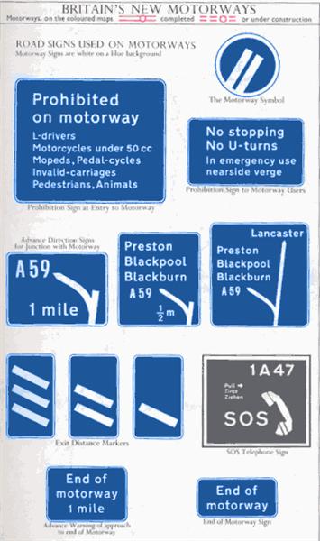
| current | 12:09, 2 July 2010 | | 355 × 600 (40 KB) | Bob@romiley1 (talk | contribs) | '''Scans from Oldhams 'NEW' Road Atlas (1963) 1.''' This page is in monochrome so I added the colour in Photoshop. Did they ever use that round Motorway sign? And a full collection of 'wonky' signs. <small>''Originally uploaded to Coppermine on Apr 03, |
File usage
There are no pages that use this file.
_1._-_Coppermine_-_243.jpg&oldid=355139)