File:Shops on Gisburn Road, Barnoldswick - Geograph - 493687.jpg

From Roader's Digest: The SABRE Wiki
Jump to navigation Jump to search

Shops_on_Gisburn_Road,_Barnoldswick_-_Geograph_-_493687.jpg(640 × 427 pixels, file size: 96 KB, MIME type: image/jpeg)

Y topleft.gifY topright.gif
Description:
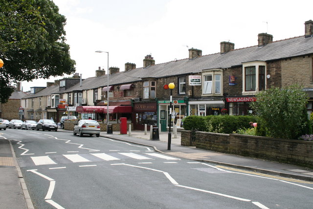
Shops on Gisburn Road, Barnoldswick
Gisburn Road (B6251) joins Barnoldswick with the A59 at Yarlside. This photograph is taken looking south-eastwards towards Barnoldswick. Some of the shop premises here have reverted to use as dwelling houses, but those that remain fulfil an important local function. From the right hand end there is a newsagent, then a vacant shop, then a post office and a butcher. The next two shops have been converted into an Italian restaurant, while a mini-mart is just beyond that. At the end of the parade is the junction with Harper Street, on the right hand side.
Location:53.920157, -2.191660
Road:b6251
Date:07 07 2007
Photographer:� Copyright Dr Neil Clifton and licensed for reuse under this Creative Commons Licence
Source:Geograph

Map

Y btmleft.gifY btmright.gif

Galleries  | b6251 | S2 | Zebra Crossing

File history

Click on a date/time to view the file as it appeared at that time.

Date/TimeThumbnailDimensionsUserComment
current14:31, 7 April 2010Thumbnail for version as of 14:31, 7 April 2010640 × 427 (96 KB)Bob@romiley1 (talk | contribs)'''Shops on Gisburn Road, Barnoldswick'''<br/>Gisburn Road (B6251) joins Barnoldswick with the A59 at Yarlside. This photograph is taken looking south-eastwards towards Barnoldswick. Some of the shop premises here have reverted to use as dwelling houses,

The following 3 pages use this file:

Metadata

SABRE - The Society for All British and Irish Road Enthusiasts
Discuss - Digest - Discover - Help