File:Soviet 15.jpg

From Roader's Digest: The SABRE Wiki
Jump to navigation Jump to search

Soviet_15.jpg(389 × 348 pixels, file size: 95 KB, MIME type: image/jpeg)

Y topleft.gifY topright.gif
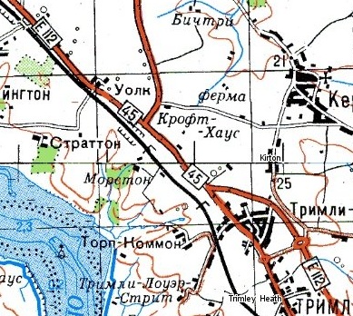
Description:E112 and A45 north of Felixstowe on Soviet map

This page includes a scan of a non-free copyrighted map, and the copyright for it is most likely held by the company or person that produced the map. It is believed that the use of a limited number of web-resolution scans qualifies as fair use under United States copyright law, where this web page is hosted, as such display does not significantly impede the right of the copyright holder to sell the copyrighted material, is not being used to generate profit in this context, and presents information that cannot be exhibited otherwise.
If the copyright holder considers this is an infringement of their rights, please contact the Site Management Team to discuss further steps.

Location:This picture currently has no coords, edit this page to add them.
Road:E112 (Old System), A45
Date:
Photographer:
Source:Soviet 1:100k mapping, accessed via http://www.topomapper.com/
Y btmleft.gifY btmright.gif

Galleries  | E112 (Old System) | A45 | Other Mapping


File history

Click on a date/time to view the file as it appeared at that time.

Date/TimeThumbnailDimensionsUserComment
current12:05, 13 March 2012Thumbnail for version as of 12:05, 13 March 2012389 × 348 (95 KB)Si404 (talk | contribs)E112 and A45 north of Felixstowe on Soviet map {{newmap}}

The following page uses this file:

Metadata

SABRE - The Society for All British and Irish Road Enthusiasts
Discuss - Digest - Discover - Help