File:Stop sign on B4519 near Upper Chapel - Geograph - 157647.jpg

From Roader's Digest: The SABRE Wiki
Jump to navigation Jump to search

Stop_sign_on_B4519_near_Upper_Chapel_-_Geograph_-_157647.jpg(640 × 480 pixels, file size: 124 KB, MIME type: image/jpeg)

Y topleft.gifY topright.gif
Description:
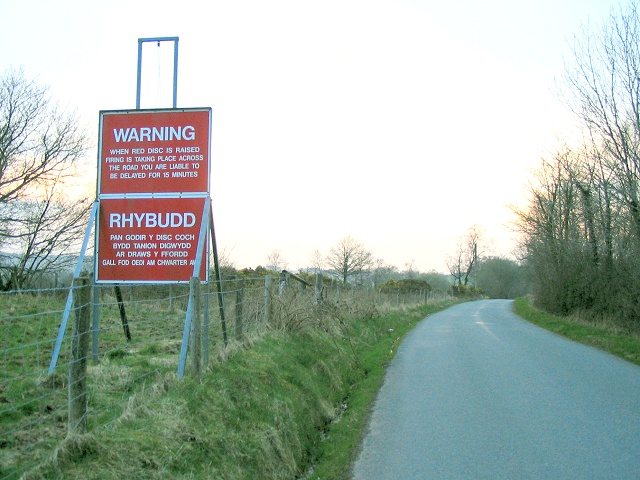
Stop sign on B4519 near Upper Chapel
As this road runs northwest into the Epynt mountain it passes through Sennybridge artillery range. This sign is used to stop traffic when weapons fire makes it unsafe to drive.
Location:52.061993, -3.454242
Road:B4519
Date:22 04 2006
Photographer:� Copyright Nigel Davies and licensed for reuse under this Creative Commons Licence
Source:Geograph

Map

Y btmleft.gifY btmright.gif

Galleries  | B4519 | Information Sign | S2

File history

Click on a date/time to view the file as it appeared at that time.

Date/TimeThumbnailDimensionsUserComment
current15:11, 18 March 2010Thumbnail for version as of 15:11, 18 March 2010640 × 480 (124 KB)Bob@romiley1 (talk | contribs)'''Stop sign on B4519 near Upper Chapel'''<br/>As this road runs northwest into the Epynt mountain it passes through Sennybridge artillery range. This sign is used to stop traffic when weapons fire makes it unsafe to drive.

The following page uses this file:

Metadata

SABRE - The Society for All British and Irish Road Enthusiasts
Discuss - Digest - Discover - Help