File:The Corratavey (or Irish) bridge - Geograph - 513925.jpg

From Roader's Digest: The SABRE Wiki
Jump to navigation Jump to search

Original file(427 × 640 pixels, file size: 102 KB, MIME type: image/jpeg)

Y topleft.gifY topright.gif
Description:
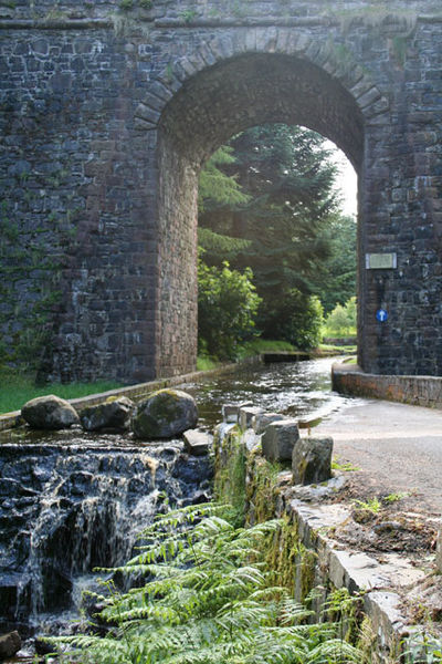
The Corratavey (or Irish) bridge
This fine arch carries the main road (A2) between Cushendall and Ballycastle over the Corratavey burn. The road under it is part of the 10km drive around Ballypatrick Forest. The driver must negotiate a shallow ford to pass under the bridge as the carriageway and the stream combine under the span. The bridge was built in 1834 by William Bald. He was also one of the chief engineers of the Cushendall to Ballycastle road.
Location:55.159151, -6.120085
Road:A2 (Northern Ireland), Causeway Coastal Route
Date:29 07 2007
Photographer:� Copyright Cormac Duffin and licensed for reuse under this Creative Commons Licence
Source:Geograph

Map

Y btmleft.gifY btmright.gif

Galleries  | A2 (Northern Ireland) | Causeway Coastal Route | Ford

File history

Click on a date/time to view the file as it appeared at that time.

Date/TimeThumbnailDimensionsUserComment
current14:08, 16 June 2010Thumbnail for version as of 14:08, 16 June 2010427 × 640 (102 KB)Si404 (talk | contribs)'''The Corratavey (or Irish) bridge'''<br/>This fine arch carries the main road (A2) between Cushendall and Ballycastle over the Corratavey burn. The road under it is part of the 10km drive around Ballypatrick Forest. The driver must negotiate a shall

The following page uses this file:

Metadata

SABRE - The Society for All British and Irish Road Enthusiasts
Discuss - Digest - Discover - Help