 | |  |
| | Description: | Approaching the summit of the road between Glamis and Petterden as it crosses the Sidlaw Hills in a south-easterly direction. | | Location: | 56.563981, -2.978771 | | Road: | A928 | | Date: | 13 03 2017 | | Photographer: | Scott Cormie | | Source: | |
|
|
| |
 | |  |
File history
Click on a date/time to view the file as it appeared at that time.
| Date/Time | Thumbnail | Dimensions | User | Comment |
|---|
| current | 18:11, 17 March 2017 | 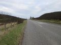 | 5,184 × 3,888 (964 KB) | Scotti (talk | contribs) | Approaching the summit of the road between Glamis and Petterden as it crosses the Sidlaw Hills in a south-easterly direction. |
File usage
The following page uses this file:
This file contains additional information, probably added from the digital camera or scanner used to create or digitise it.
If the file has been modified from its original state, some details may not fully reflect the modified file.

