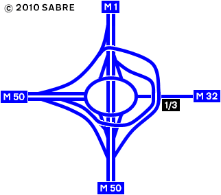
File:Turnapin Interchange 2011.PNG
Jump to navigation
Jump to search

No higher resolution available.
Turnapin_Interchange_2011.PNG (322 × 284 pixels, file size: 11 KB, MIME type: image/png)
| |||||||||||||||||||||||||
|
Galleries | M50 (Republic of Ireland) | M1 (Republic of Ireland) | M32 (Republic of Ireland) | Turnapin Interchange | Strip Maps | ||
File history
Click on a date/time to view the file as it appeared at that time.
| Date/Time | Thumbnail | Dimensions | User | Comment | |
|---|---|---|---|---|---|
| current | 08:27, 17 March 2012 | | 322 × 284 (11 KB) | Abeaton (talk | contribs) | Turnapin Interchange as it was in 2011 |
File usage
The following 2 pages use this file: