Ford Bridge
Jump to navigation
Jump to search
| Ford Bridge | |||||
| Location Map ( geo) | |||||
 | |||||
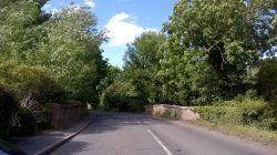
| Heading north on the B1368 | |||||
| |||||
| Location | |||||
| Braughing | |||||
| County | |||||
| Hertfordshire | |||||
| Highway Authority | |||||
| Hertfordshire | |||||
| Opening Date | |||||
| 1667 | |||||
| Additional Information | |||||
| |||||
| On road(s) | |||||
| B1368 | |||||
| Crossings related to the B1368 | |||||
Ford Bridge is a Grade II listed structure which carries the B1368 and long distance GMT walking trail over the River Rib, between Puckeridge and Braughing, in Hertfordshire.
The present bridge is a two lane bridge with narrow footway on one side and low brick parapets. It is made of brick of Flemish Bond construction, and has two arches spanning the river. It dates from 1667[1]. It replaced an earlier wooden bridge, and was repaired in 1773.
It was listed on the local authority's "Heritage at Risk" register in 2006 (updated in 2016)[2], and featured again in 2019[3]
References
- ↑ British History Online: A History of the County of Hertford Vol. 3 > Parishes: Braughing (1912) (archive.org)
- ↑ East Hertfordshire District Council:Braughing Conservation Area Character Appraisal and Management Proposals (14.12.2016) (archive.org)
- ↑ East Hertfordshire District Council - Heritage at Risk Register (2018/9) (archive.org)
