Fox House
Jump to navigation
Jump to search
| Fox House | |||
| Location Map ( geo) | |||
 | |||
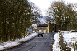
| A snowy Fox House Junction, with Inn on the junction ahead | |||
| |||
| Location | |||
| Longshaw | |||
| County | |||
| Derbyshire | |||
| Highway Authority | |||
| Derbyshire • Sheffield | |||
| Junction Type | |||
| T junction on bend | |||
| Roads Joined | |||
| A6187 Owler Bar Road, A6187 Hathersage Road | |||
Fox House is T junction on a bend near the Longshaw estate in Derbyshire.
The junction is named after the Fox House Inn, which sits on the inside of the bend. The junction is interesting from a roads perspective as all three arms are numbered A6187, although only the flag and Advance Direction signs in the Castleton direction show this.
Just to the west of the junction is another T junction with the B6521 - which appears not to form part of the Fox House junction on the Advance Direction signs, it would certainly be used as a direction point for navigation purposes!
Routes
| Route | To | Notes |
| Sheffield (A625) | A6187 number unsigned | |
| Chesterfield (B6051); Dronfield | A6187 number unsigned | |
| Hope, Castleton, Hathersage |
| Fox House | ||
|


