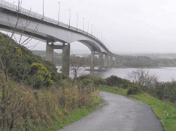
Foyle Bridge
| Foyle Bridge | |||||
| Location Map ( geo) | |||||
 | |||||
| The bridge in 2006 | |||||
| |||||
| From: | Gransh | ||||
| To: | Steelstown | ||||
| Location | |||||
| Derry | |||||
| County | |||||
| Londonderry | |||||
| Highway Authority | |||||
| DfI Roads | |||||
| Opening Date | |||||
| 1984 | |||||
| Additional Information | |||||
| |||||
| On road(s) | |||||
| A515 | |||||
The Foyle Bridge is a dual carriageway road bridge that carries the A515 over the River Foyle, that allows through traffic between Northern Ireland and Donegal to bypass Derry City Centre.
The bridge was one of the recommendations of the Cross-Border Communications Study for the Londonderry and Donegal Area undertaken by the Commission of the European Communities. Tenders were invited in 1979. The steelwork for the Foyle Bridge was fabricated by Harland & Wolff in Belfast and transported to the Foyle by barge.
The bridge opened in 1984, and provided much needed relief for traffic, all of which could only cross the Foyle via the 1930s Craigavon Bridge. It has a span of 234m.
From 2003 - 2005, the bridge underwent a major refurbishment, in order to be better strengthened to cater for HGV traffic.
| Foyle Bridge | ||
| ||
|


