Star.pngStar.pngStar grey.pngStar grey.pngStar grey.png

Framwellgate Bridge

From Roader's Digest: The SABRE Wiki
Jump to navigation Jump to search
Framwellgate Bridge
Location Map ( geo)
Framwelgate Bridge, Durham - Geograph - 3840624.jpg
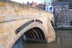
The south side of the bridge in 2015
Cameraicon.png View gallery (1)
Location
Durham
County
Durham
Highway Authority
Durham
Opening Date
Early C15
Additional Information
List No:  1322872  (Grade I)
Bridge Type:  Arch Bridge

Framwellgate Bridge is a grade I listed stone multiple arch bridge crosses the River Wear in Durham city centre. It is built on the site of an earlier C13 bridge.


The bridge has undergone several alterations during its life, including widening in early C19.


Framwellgate Bridge
Related Pictures
View gallery (1)
Framwelgate Bridge, Durham - Geograph - 3840624.jpg
Crossings of the River Wear
Wearhead Bridge • Daddryshield Bridge • Stanhope Bridge • Witton Bypass Bridge • Newton Cap Viaduct • Croxdale Bridge • Shincliffe Bridge • Baths Bridge • New Elvet Bridge • Elvet Bridge • Prebends Bridge • Framwellgate Bridge • Milburngate Bridge • Lumley Bridge • Wear Viaduct (A1(M)) • Lambton Bridge • Chester New Bridge • Chartershaugh Bridge • East Bridge • Hylton Viaduct • Northern Spire • Queen Alexandra Bridge • Wearmouth Bridge

SABRE - The Society for All British and Irish Road Enthusiasts
Discuss - Digest - Discover - Help