Gallery:B6042
From Roader's Digest: The SABRE Wiki
Jump to navigation
Jump to search
B6000-B6099 > B6042
This gallery has no child categories
B6042
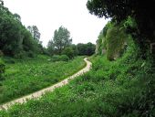
Creswell - former route of B6042 road (C) Dave Bevis
Former B6042 road at the eastern end of the Creswell Crags gorge, viewed from the steps up to Robin Hood's Cave. It became a bridleway in 2007, following the diversion to the north of a 900m length of the B6042. The aim was to minimise the impact of traffic on Creswell Crags (both in terms of vibration damage to the fragile limestone crags and making it a more pleasant environment for visitors to the gorge and associated visitor centre). In the preceding 10-or-so years, the original full-width road had been reduced to a single-lane road controlled by traffic lights at both ends of the gorge. For details of the Creswell Crags Visitor Centre, please see <a title='http://www.creswell-crags.org.uk/' rel='nofollow' href='http://www.creswell-crags.org.uk/'>Link</a><img style='padding-left:2px;' alt='External link' title='External link - shift click to open in new window' src='http://s1.geograph.org.uk/img/external.png' width='10' height='10'/> .
Former B6042 road at the eastern end of the Creswell Crags gorge, viewed from the steps up to Robin Hood's Cave. It became a bridleway in 2007, following the diversion to the north of a 900m length of the B6042. The aim was to minimise the impact of traffic on Creswell Crags (both in terms of vibration damage to the fragile limestone crags and making it a more pleasant environment for visitors to the gorge and associated visitor centre). In the preceding 10-or-so years, the original full-width road had been reduced to a single-lane road controlled by traffic lights at both ends of the gorge. For details of the Creswell Crags Visitor Centre, please see <a title='http://www.creswell-crags.org.uk/' rel='nofollow' href='http://www.creswell-crags.org.uk/'>Link</a><img style='padding-left:2px;' alt='External link' title='External link - shift click to open in new window' src='http://s1.geograph.org.uk/img/external.png' width='10' height='10'/> .
Hidden categories:

