Gallery:B6293
From Roader's Digest: The SABRE Wiki
Jump to navigation
Jump to search
B6200-B6299 > B6293
This gallery has no child categories
B6293
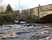
Upper Wear- put in at Wearhead
The section of the River Wear from Wearhead to Stanhope is what paddlers mean by the Upper Wear. A waterfall just upstream from here is much harder than anything on this stretch of the river, and the most convenient place to put on is from the public footpath river right downstream of the main road bridge in Wearhead. In lower water, one can walk under the arch seen here, and put on a little further up to paddle under the river left arch (not visible in the picture). However, this is a good level, and if low enough to walk under the arch, there will be a few places lower down which are a bump and scrape.
The section of the River Wear from Wearhead to Stanhope is what paddlers mean by the Upper Wear. A waterfall just upstream from here is much harder than anything on this stretch of the river, and the most convenient place to put on is from the public footpath river right downstream of the main road bridge in Wearhead. In lower water, one can walk under the arch seen here, and put on a little further up to paddle under the river left arch (not visible in the picture). However, this is a good level, and if low enough to walk under the arch, there will be a few places lower down which are a bump and scrape.
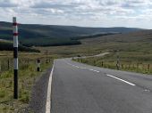
A Road Summit
The highest point of the highest A road in the country (the A689), on the Cumbria - Durham border.
Originally uploaded to Coppermine on Oct 17, 2006 by HelvellynHidden categories:


