Gallery:C134 (Cambridgeshire)

From Roader's Digest: The SABRE Wiki
Jump to navigation Jump to search
Class III Roads (Cambridgeshire) > C134 (Cambridgeshire)


This gallery has no child categories
C134 (Cambridgeshire)
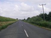
 
 
20180602-1219 - C134 Branch Bank, East of Queen Adelaide 52.4119195N 0.3020908E.jpg
C134 Branch Bank, East of Queen Adelaide
20180602-1221 - Road on the Bank of the River Ouse (C134) 52.4166657N 0.3044863E -cropped.jpg
Road on the Bank of the River Ouse (C134)
20180602-1221 - Farmland to the East of Queen Adelaide, near Clay Way Farm 52.4230391N 0.3084797E - cropped.jpg
Farmland to the East of Queen Adelaide, near Clay Way Farm The C134 runs along the bank of the River Great Ouse in the left of the photograph
 

SABRE - The Society for All British and Irish Road Enthusiasts
Discuss - Digest - Discover - Help